|
search place name
|
||
Ihawa (Uva, Sri Lanka)Ihawa is a town in the Uva region of Sri Lanka. An overview map of the region around Ihawa is displayed below.
regional and 3d topo map of Ihawa, Sri Lanka ::

Ihawa airports ::
The nearest airport is GOY - Galoya Amparai, located 43.9 km north east of Ihawa.
Other airports nearby include RML - Colombo Ratmalana (170.3 km west), CMB - Bandaranaike Intl Colombo (170.5 km west), TRR - Trinciomalee China Bay (172.1 km north), Nearby towns ::
Karandegangoda (1.8km west) //
Gangodagama (1.9km north) //
Watawanagama (1.9km north) //
Kinwelgoda (2.6km south east) //
Uyanabedda (2.6km north east) //
Pansalwatta (2.6km south west) //
Puwakgoda (2.6km south west) //
Talkota (3.7km north) //
Madawalanda (4.1km north east) //
Kolladeniya (4.1km south east) //
Alpitiya (4.1km south west) //
Henditiyawa (4.1km south west) //
Gangoda-arawa (5.2km south east) //
Kehellanda (5.2km south west) //
Deliwa (5.2km north west) //
Revulvala (5.2km north west) //
Makulla (5.5km west) //
Kottagala (5.6km south) //
Bummane (5.9km north) //
Miyalgala (5.9km north) //
Galmulla (5.9km north) //
Magandena (5.8km west) //
Makullewatta (5.8km west) //
Marakkanawa (5.8km west) //
Ritigahawatta (5.8km east) //
Mariarawa (5.8km east) //
Udumulla (6.6km south west) //
Miyalgala (7.4km east) //
Moragahapitiya (7.4km east) //
[all distances 'as the bird flies' and approximate] 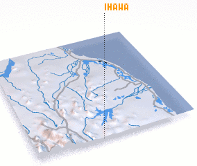 Places with similar names to Ihawa, Sri Lanka :: Disclaimer :: Information on this page comes without warranty of any kind |
||
|
Where is Ihawa? Elevation and coordinates ::
Latitude (lat): 7°0'0"N Longitude (lon): 81°25'0"E
Elevation (approx.): 184m (map arrows pan, magnifying glasses zoom) |
||
|
Visiting Ihawa? Hotel/Accommodation ::
Book a hotel in Ihawa Travel Guide ::
Buy a travel guide for Sri Lanka rental cars ::
car rental offers GPS waypoint ::
download a GPX waypoint (PoI) of Ihawa for your GPS receiver
|
||