|
search place name
|
||
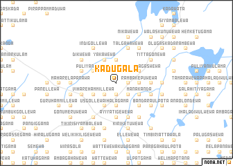
Kadugala (North Central, Sri Lanka)Kadugala is a town in the North Central region of Sri Lanka. An overview map of the region around Kadugala is displayed below.
regional and 3d topo map of Kadugala, Sri Lanka ::
Kadugala airports ::
The nearest airport is TRR - Trinciomalee China Bay, located 55.4 km east of Kadugala.
Other airports nearby include JAF - Jaffna Kankesanturai (140.8 km north west), GOY - Galoya Amparai (180.5 km south east), CMB - Bandaranaike Intl Colombo (189.0 km south west), RML - Colombo Ratmalana (224.6 km south west), Nearby towns ::
Italwiddawewa (1.9km south) //
Galawewa (1.8km east) //
Kohombagaswewa (1.8km east) //
Ihalawewa (2.6km south west) //
Mahanetiyawa (2.6km south east) //
Kongollewa (2.6km north west) //
Rambakepuwewa (3.7km east) //
Usgollewa Pahalagama (3.7km south) //
Kanugahaulpota (3.7km north) //
Elapattewa (4.1km south east) //
Manakanda (4.1km south east) //
Vihare Hammillewa (4.1km south west) //
Siyambalagaswewa (4.1km north east) //
Usgollewa Ihalagama (4.1km south west) //
Puliyankulama (4.1km north west) //
Hammillawetiya (4.1km north west) //
Yakawewa (4.1km north west) //
Punchi Hammillewa (5.2km south east) //
Sinhala Etawirawewa (5.2km south east) //
Mudakanda (5.5km east) //
Ayiyatigewewa (5.6km south) //
Kunchuttuwa (5.8km west) //
Kuda Nambadawewa (5.8km east) //
Kuda Relapanawa (5.8km west) //
Lunuatulewa (5.9km south) //
Talgahawewa (5.9km north) //
Ulpatgama (6.7km south east) //
Dunukeyiyaulpota (6.7km south east) //
Bandara Ulpota (6.6km south east) //
[all distances 'as the bird flies' and approximate]  Places with similar names to Kadugala, Sri Lanka ::
Disclaimer :: Information on this page comes without warranty of any kind |
||
|
Where is Kadugala? Elevation and coordinates ::
Latitude (lat): 8°41'0"N Longitude (lon): 80°42'0"E
Elevation (approx.): 104m (map arrows pan, magnifying glasses zoom) |
||
|
Visiting Kadugala? Hotel/Accommodation ::
Book a hotel in Kadugala Travel Guide ::
Buy a travel guide for Sri Lanka rental cars ::
car rental offers GPS waypoint ::
download a GPX waypoint (PoI) of Kadugala for your GPS receiver
|
||