|
search place name
|
||
Kayavantankulachchenai (North Eastern, Sri Lanka)Kayavantankulachchenai is a town in the North Eastern region of Sri Lanka. An overview map of the region around Kayavantankulachchenai is displayed below.
regional and 3d topo map of Kayavantankulachchenai, Sri Lanka ::

Kayavantankulachchenai airports ::
The nearest airport is TRR - Trinciomalee China Bay, located 14.9 km north west of Kayavantankulachchenai.
Other airports nearby include GOY - Galoya Amparai (127.5 km south), JAF - Jaffna Kankesanturai (199.7 km north west), CMB - Bandaranaike Intl Colombo (206.0 km south west), RML - Colombo Ratmalana (234.4 km south west), Nearby towns ::
Mutur (1.9km north) //
Paravippanchan (1.8km west) //
Vedativu (1.8km west) //
Kaddaiparichchan (2.6km north east) //
Kuruvittivu (2.6km north west) //
Uppukkachchimadu (2.6km north west) //
Pachchanur (3.7km south) //
Periyaveli (3.7km south) //
Manatchenai (3.7km south) //
Pallikudiyiruppu (4.1km south east) //
Padditidal (4.1km south east) //
Marutadichchenai (4.1km north east) //
Navaladi (4.1km north west) //
Navaladitoddam (4.1km north west) //
Navaladimukattuvaram (4.1km north west) //
Rakkuli (4.1km north west) //
Panvaddavan (4.1km north west) //
Kadalkaraichchenai (5.2km north east) //
Sunkankuli (5.2km north east) //
Gangai (5.2km north west) //
Sampalchenai (5.6km south) //
Topputtidal (5.6km south) //
Mallikaitivu (5.6km south) //
Udaiyamadam (5.9km south) //
Palattadichchenai (5.9km south) //
Sampur (5.9km north) //
Nilappalai (5.9km south) //
Palatoppu (6.7km south east) //
Toppur (6.6km south east) //
[all distances 'as the bird flies' and approximate] 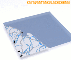 Places with similar names to Kayavantankulachchenai, Sri Lanka :: Disclaimer :: Information on this page comes without warranty of any kind |
||
|
Where is Kayavantankulachchenai? Elevation and coordinates ::
Latitude (lat): 8°26'0"N Longitude (lon): 81°16'0"E
Elevation (approx.): 12m (map arrows pan, magnifying glasses zoom) |
||
|
Visiting Kayavantankulachchenai? Hotel/Accommodation ::
Book a hotel in Kayavantankulachchenai Travel Guide ::
Buy a travel guide for Sri Lanka rental cars ::
car rental offers GPS waypoint ::
download a GPX waypoint (PoI) of Kayavantankulachchenai for your GPS receiver
|
||