|
search place name
|
||
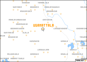
Udamattala (Southern, Sri Lanka)Udamattala is a town in the Southern region of Sri Lanka. An overview map of the region around Udamattala is displayed below.
regional and 3d topo map of Udamattala, Sri Lanka ::
Udamattala airports ::
The nearest airport is GOY - Galoya Amparai, located 123.6 km north east of Udamattala.
Other airports nearby include RML - Colombo Ratmalana (148.1 km west), CMB - Bandaranaike Intl Colombo (166.9 km north west), Nearby towns ::
Malasnegalewewa (3.7km west) //
Padavkema (4.1km north east) //
Unatuwewa (4.1km north east) //
Ranawaranawewa (5.5km west) //
Punchiappujandura (5.8km east) //
Kurundana (6.7km south west) //
Lunuganwehera (7.4km east) //
Elalla (7.6km west) //
Kotakumbukka (7.6km north) //
Bogahawewa (8.3km north east) //
Medagama (10.5km north west) //
Anukkangala (10.5km north west) //
Sittarama (10.5km north east) //
[all distances 'as the bird flies' and approximate] 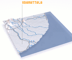 Places with similar names to Udamattala, Sri Lanka :: Disclaimer :: Information on this page comes without warranty of any kind |
||
|
Where is Udamattala? Elevation and coordinates ::
Latitude (lat): 6°20'0"N Longitude (lon): 81°8'0"E
Elevation (approx.): 69m (map arrows pan, magnifying glasses zoom) |
||
|
Visiting Udamattala? Hotel/Accommodation ::
Book a hotel in Udamattala Travel Guide ::
Buy a travel guide for Sri Lanka rental cars ::
car rental offers GPS waypoint ::
download a GPX waypoint (PoI) of Udamattala for your GPS receiver
|
||