|
search place name
|
||
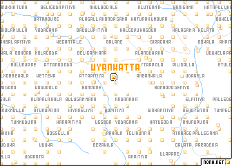
Uyanwatta (Sabaragamuwa, Sri Lanka)Uyanwatta is a town in the Sabaragamuwa region of Sri Lanka. An overview map of the region around Uyanwatta is displayed below.
regional and 3d topo map of Uyanwatta, Sri Lanka ::
Uyanwatta airports ::
The nearest airport is CMB - Bandaranaike Intl Colombo, located 66.3 km west of Uyanwatta.
Other airports nearby include RML - Colombo Ratmalana (79.1 km south west), GOY - Galoya Amparai (126.9 km east), TRR - Trinciomalee China Bay (165.2 km north east), Nearby towns ::
Udugala (0.0km north) //
Ayagama (0.0km north) //
Medagoda (0.0km north) //
Rukulegama (0.0km north) //
Weraka (0.0km north) //
Paranagama (0.0km north) //
Ruwandeniya (1.8km west) //
Palle Pamunuwa (1.8km west) //
Dewanagala (1.8km west) //
Karahanpitigoda (1.8km west) //
Kekirigoda (1.8km west) //
Molligoda (1.9km north) //
Kendaragama (1.9km north) //
Batawala (1.9km north) //
Kumbalgama (1.9km south) //
Dompitiya (1.9km south) //
Siyambalawa (1.9km south) //
Balawatgama (1.9km south) //
Mipitiya (1.9km south) //
Rukmale (1.9km south) //
Uhangoda (2.6km north west) //
Kongamuwa (2.6km north west) //
Maliyadda (2.6km north west) //
Edanduwawa (2.6km north west) //
Gallella (2.6km north west) //
Idampitiya (2.6km north west) //
Kotabogoda (2.6km north west) //
Manikkawa (2.6km north west) //
Alutnuwara (2.6km north west) //
[all distances 'as the bird flies' and approximate] 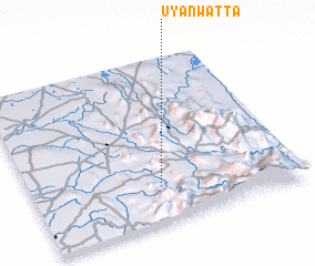 Places with similar names to Uyanwatta, Sri Lanka :: Disclaimer :: Information on this page comes without warranty of any kind |
||
|
Where is Uyanwatta? Elevation and coordinates ::
Latitude (lat): 7°13'0"N Longitude (lon): 80°29'0"E
Elevation (approx.): 237m (map arrows pan, magnifying glasses zoom) |
||
|
Visiting Uyanwatta? Hotel/Accommodation ::
Book a hotel in Uyanwatta Travel Guide ::
Buy a travel guide for Sri Lanka rental cars ::
car rental offers GPS waypoint ::
download a GPX waypoint (PoI) of Uyanwatta for your GPS receiver
|
||