|
search place name
|
||
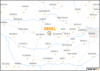
Abwel (Busoga, Uganda)Abwel is a town in the Busoga region of Uganda. An overview map of the region around Abwel is displayed below.
regional and 3d topo map of Abwel, Uganda ::
Abwel airports ::
The nearest airport is KTL - Kitale, located 107.1 km east of Abwel.
Other airports nearby include KIS - Kisumu (115.0 km south east), SRT - Soroti (123.9 km north), EDL - Eldoret Intl (137.2 km east), EBB - Entebbe Intl (191.4 km west), Nearby towns ::
Pajwenda (3.1km east) //
Mwelo (3.2km north) //
Mulanda (3.6km west) //
Lwala (4.3km south) //
Bira (5.1km east) //
Kisote (5.6km north west) //
Mulanda (6.3km west) //
Agola (6.6km east) //
Magola (7.3km south) //
Morkisuwa (7.4km north east) //
Kosoko (7.7km north east) //
Katerema (8.1km south east) //
Nagongera (8.3km north) //
Kidera (8.7km east) //
Osia (9.0km east) //
Podoti (9.4km south east) //
Buyemba (11.7km south east) //
Nyemera (12.2km south west) //
[all distances 'as the bird flies' and approximate] 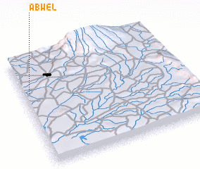 Places with similar names to Abwel, Uganda ::
Disclaimer :: Information on this page comes without warranty of any kind |
||
|
Where is Abwel? Elevation and coordinates ::
Latitude (lat): 0°41'17"S Longitude (lon): 34°2'20"E
Elevation (approx.): 1140m (map arrows pan, magnifying glasses zoom) |
||
|
Visiting Abwel? Hotel/Accommodation ::
Book a hotel in Abwel Travel Guide ::
Buy a travel guide for Uganda rental cars ::
car rental offers GPS waypoint ::
download a GPX waypoint (PoI) of Abwel for your GPS receiver
|
||