|
search place name
|
||
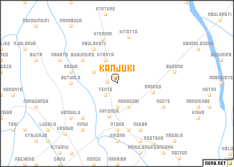
Kanjuki (Busoga, Uganda)Kanjuki is a town in the Busoga region of Uganda. An overview map of the region around Kanjuki is displayed below.
regional and 3d topo map of Kanjuki, Uganda ::
Kanjuki airports ::
The nearest airport is EBB - Entebbe Intl, located 93.3 km south west of Kanjuki.
Other airports nearby include SRT - Soroti (134.8 km north east), KIS - Kisumu (223.6 km south east), Nearby towns ::
Ntenjeru (1.7km west) //
Tente (2.6km south west) //
Kisawo (3.7km south) //
Buyobe (4.1km north west) //
Kyanya (4.1km north west) //
Namagabi (4.1km south east) //
Kayunga (5.4km south) //
Mpongo (5.9km east) //
Mbulakati (6.7km north west) //
Buwungiro (6.7km north west) //
Butwala (7.4km west) //
Ntoke (7.4km south) //
Kyerima (7.5km north) //
Magwa (7.6km west) //
Bukoloto (7.6km south) //
Kitatya (7.6km north) //
Nakasenyi (7.9km south west) //
Ngeye (8.3km south east) //
Ndeba (8.3km south east) //
Mindi (9.3km south west) //
Wandulu (9.3km south west) //
Kasawo (11.6km south west) //
[all distances 'as the bird flies' and approximate] 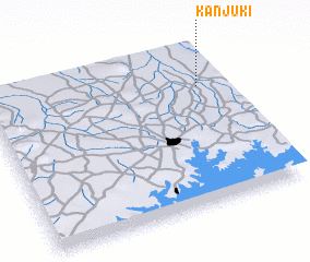 Places with similar names to Kanjuki, Uganda ::
Disclaimer :: Information on this page comes without warranty of any kind |
||
|
Where is Kanjuki? Elevation and coordinates ::
Latitude (lat): 0°45'0"S Longitude (lon): 32°54'0"E
Elevation (approx.): 1075m (map arrows pan, magnifying glasses zoom) |
||
|
Visiting Kanjuki? Hotel/Accommodation ::
Book a hotel in Kanjuki Travel Guide ::
Buy a travel guide for Uganda rental cars ::
car rental offers GPS waypoint ::
download a GPX waypoint (PoI) of Kanjuki for your GPS receiver
|
||