|
search place name
|
||
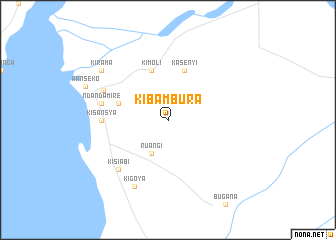
Kibambura (Busoga, Uganda)Kibambura is a town in the Busoga region of Uganda. An overview map of the region around Kibambura is displayed below.
regional and 3d topo map of Kibambura, Uganda ::
Kibambura airports ::
The nearest airport is BUX - Bunia, located 152.9 km south west of Kibambura.
Nearby towns ::
Ruangi (4.1km south west) //
Kasenyi (5.9km north) //
Bikongoro (5.9km west) //
Bukindwa (5.9km north) //
Kimoli (5.9km north) //
Kisansya (7.4km west) //
Kigwera (7.6km west) //
Ndandamire (7.6km west) //
Kisiabi (7.9km south west) //
Bulisa (7.9km north west) //
Kigoya (8.3km south west) //
Kirama (9.3km north west) //
[all distances 'as the bird flies' and approximate]  Places with similar names to Kibambura, Uganda ::
// Kabambare (CD)
// Kabambare (CD)
// Kibumbiro (TZ)
// Cabo Mário (MZ)
// Cabo Mire (MZ)
// Cabo Moria (MZ)
// Cabo Murri (MZ)
// Cabo Murri (MZ)
// Kebaimeri (PG)
// Ka‘b-e ‘Omeyr (IR)
Disclaimer :: Information on this page comes without warranty of any kind |
||
|
Where is Kibambura? Elevation and coordinates ::
Latitude (lat): 2°9'0"N Longitude (lon): 31°28'0"E
Elevation (approx.): 672m (map arrows pan, magnifying glasses zoom) |
||
|
Visiting Kibambura? Hotel/Accommodation ::
Book a hotel in Kibambura Travel Guide ::
Buy a travel guide for Uganda rental cars ::
car rental offers GPS waypoint ::
download a GPX waypoint (PoI) of Kibambura for your GPS receiver
|
||