|
search place name
|
||
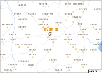
Kyanja (Busoga, Uganda)Kyanja is a town in the Busoga region of Uganda. An overview map of the region around Kyanja is displayed below.
regional and 3d topo map of Kyanja, Uganda ::
Kyanja airports ::
The nearest airport is EBB - Entebbe Intl, located 91.5 km north east of Kyanja.
Other airports nearby include KGL - Kigali Intl (251.6 km south west), BUX - Bunia (267.4 km north west), Nearby towns ::
Kyabakuza (1.2km west) //
Gayaza (2.1km south) //
Masaka (2.2km north) //
Budda (3.7km north) //
Kabukulwa (4.6km north west) //
Nyendo (5.0km north east) //
Bisanje (5.8km south) //
Kaganda (5.8km south) //
Kyamagoma (6.2km north west) //
Kisojjo (6.2km north west) //
Kitovu (6.3km east) //
Bulando (6.6km east) //
Kyakatebe (7.3km north) //
Kalua (8.0km north east) //
Nkoni (8.6km west) //
Kikungwe (8.8km south west) //
Ssenya (8.8km south west) //
Kitwe (9.0km south east) //
Kabwami (9.4km south west) //
Kasanje (9.6km north east) //
Kyalusowe (9.8km north east) //
Mukoni (9.8km south east) //
Butale (10.1km south west) //
Misanvu (10.2km north west) //
[all distances 'as the bird flies' and approximate] 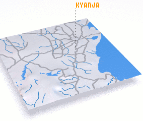 Places with similar names to Kyanja, Uganda ::
Disclaimer :: Information on this page comes without warranty of any kind |
||
|
Where is Kyanja? Elevation and coordinates ::
Latitude (lat): 0°19'55"S Longitude (lon): 31°42'37"E
Elevation (approx.): 1204m (map arrows pan, magnifying glasses zoom) |
||
|
Visiting Kyanja? Hotel/Accommodation ::
Book a hotel in Kyanja Travel Guide ::
Buy a travel guide for Uganda rental cars ::
car rental offers GPS waypoint ::
download a GPX waypoint (PoI) of Kyanja for your GPS receiver
|
||