|
search place name
|
||
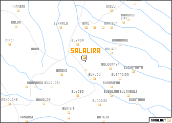
Salalira (Busoga, Uganda)Salalira is a town in the Busoga region of Uganda. An overview map of the region around Salalira is displayed below.
regional and 3d topo map of Salalira, Uganda ::
Salalira airports ::
The nearest airport is KTL - Kitale, located 78.8 km east of Salalira.
Other airports nearby include SRT - Soroti (93.1 km north west), EDL - Eldoret Intl (139.0 km south east), KIS - Kisumu (153.5 km south), EBB - Entebbe Intl (245.0 km south west), Nearby towns ::
Mutufu (1.9km south) //
Sironko (1.9km north) //
Buhugu (4.1km south east) //
Buyaga (4.1km north west) //
Buluganya (5.5km east) //
Bulago (5.9km east) //
Siroko (6.0km south west) //
Muyembe (7.4km north) //
Simu (7.4km north) //
Buyobo (7.6km south) //
Buligenyi (7.6km north) //
Bumasifwa (7.9km south east) //
Bugwa (8.3km north east) //
Butandiga (8.3km south east) //
Bumwambu (8.3km north east) //
Busulani (9.3km south east) //
Bukhalu (9.3km north west) //
Buwalasi (9.3km south west) //
Namisuni (9.3km north east) //
Sipi (11.8km north east) //
[all distances 'as the bird flies' and approximate] 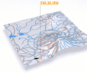 Places with similar names to Salalira, Uganda ::
Disclaimer :: Information on this page comes without warranty of any kind |
||
|
Where is Salalira? Elevation and coordinates ::
Latitude (lat): 1°14'0"N Longitude (lon): 34°18'0"E
Elevation (approx.): 1166m (map arrows pan, magnifying glasses zoom) |
||
|
Visiting Salalira? Hotel/Accommodation ::
Book a hotel in Salalira Travel Guide ::
Buy a travel guide for Uganda rental cars ::
car rental offers GPS waypoint ::
download a GPX waypoint (PoI) of Salalira for your GPS receiver
|
||