|
search place name
|
||
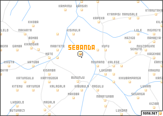
Sebanda (Busoga, Uganda)Sebanda is a town in the Busoga region of Uganda. An overview map of the region around Sebanda is displayed below.
regional and 3d topo map of Sebanda, Uganda ::
Sebanda airports ::
The nearest airport is EBB - Entebbe Intl, located 69.0 km south east of Sebanda.
Other airports nearby include SRT - Soroti (200.4 km north east), BUX - Bunia (244.0 km north west), Nearby towns ::
Kadunda (4.1km north east) //
Nvunano (4.1km south east) //
Busunju (5.5km south) //
Kizigo (5.6km west) //
Kufu (5.9km east) //
Kileku (5.9km east) //
Nabitete (5.9km west) //
Kisimula (5.9km north) //
Lukumbi (6.7km south east) //
Kibubula (7.4km south) //
Mate (7.4km west) //
Kalege (7.6km east) //
Kabulamuliro (7.9km north west) //
Nagulu (8.3km south east) //
Kyanuna (8.3km south east) //
Kyajinja (8.3km south east) //
Kisamba (8.3km south west) //
Kapeka (9.2km north east) //
Bukuku (9.3km south east) //
Kalagala (9.3km south west) //
Kanyogoga (9.3km south west) //
[all distances 'as the bird flies' and approximate] 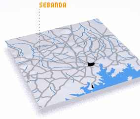 Places with similar names to Sebanda, Uganda ::
Disclaimer :: Information on this page comes without warranty of any kind |
||
|
Where is Sebanda? Elevation and coordinates ::
Latitude (lat): 0°37'0"S Longitude (lon): 32°12'0"E
Elevation (approx.): 1109m (map arrows pan, magnifying glasses zoom) |
||
|
Visiting Sebanda? Hotel/Accommodation ::
Book a hotel in Sebanda Travel Guide ::
Buy a travel guide for Uganda rental cars ::
car rental offers GPS waypoint ::
download a GPX waypoint (PoI) of Sebanda for your GPS receiver
|
||