|
search place name
|
||
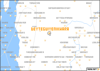
Dey Tégui Yéni Kwara (Dosso, Niger)Dey Tégui Yéni Kwara is a town in the Dosso region of Niger. An overview map of the region around Dey Tégui Yéni Kwara is displayed below.
regional and 3d topo map of Dey Tégui Yéni Kwara, Niger ::
Dey Tégui Yéni Kwara airports ::
The nearest airport is NIM - Niamey Diori Hamani, located 98.3 km west of Dey Tégui Yéni Kwara.
Nearby towns ::
Kodey (1.9km north) //
Boulaga (2.6km south west) //
Danda (4.1km north west) //
Kabé (5.9km west) //
Kokorbé (6.6km south east) //
Midawa (6.6km north east) //
Borgo Gorou (6.6km north west) //
Sinnsan Kwara Zéno (6.6km south east) //
Daré (6.6km north east) //
Goubé Zéno (7.4km west) //
Kobé Béri (7.8km south west) //
Dey Tégui Fandou (7.8km north east) //
Borgo Béri (8.2km north west) //
Zouzoumadey (9.1km south east) //
Marafa Kwara (9.2km south west) //
Tiassoboba Kwara (9.2km south west) //
[all distances 'as the bird flies' and approximate] 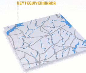 Places with similar names to Dey Tégui Yéni Kwara, Niger :: Disclaimer :: Information on this page comes without warranty of any kind |
||
|
Where is Dey Tégui Yéni Kwara? Elevation and coordinates ::
Latitude (lat): 13°36'0"N Longitude (lon): 3°5'0"E
Elevation (approx.): 237m (map arrows pan, magnifying glasses zoom) |
||
|
Visiting Dey Tégui Yéni Kwara? Hotel/Accommodation ::
Book a hotel in Dey Tégui Yéni Kwara Travel Guide ::
Buy a travel guide for Niger rental cars ::
car rental offers GPS waypoint ::
download a GPX waypoint (PoI) of Dey Tégui Yéni Kwara for your GPS receiver
|
||