|
search place name
|
||
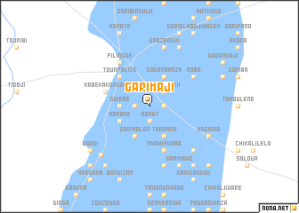
Gari Maji (Niamey, Niger)Gari Maji is a town in the Niamey region of Niger. An overview map of the region around Gari Maji is displayed below.
regional and 3d topo map of Gari Maji, Niger ::
Gari Maji airports ::
The nearest airport is NIM - Niamey Diori Hamani, located 155.2 km south west of Gari Maji.
Other airports nearby include THZ - Tahoua (216.0 km east), SKO - Sokoto Sadiq Abubakar Iii Intl (252.6 km south east), Nearby towns ::
Takaouat I (1.8km east) //
Maray (1.9km south) //
Kankoura (1.8km east) //
Gari Miza (1.8km west) //
Takaouat II (2.6km north east) //
Guiébé (3.6km west) //
Dogon Banza (4.1km north east) //
Maraké (4.0km south west) //
Taramna (4.1km south east) //
Gari Malan (4.1km south west) //
Tounfalizé (5.2km north west) //
Kabékakongou (5.7km west) //
Rwahinkaba (5.8km south) //
Filingué (6.6km north west) //
Noba (6.5km north east) //
Gao Zengui (7.6km north) //
Gari Irkwénon (7.6km south) //
Gari Agui (7.7km south east) //
Dodamey (8.2km north east) //
Gari Gaziri (8.1km south east) //
Magaria (8.1km south east) //
Garim Bwé (8.2km south east) //
Gao (8.5km south west) //
Gari Mayaki (9.2km south east) //
Gardi (9.1km south west) //
Gao Sabon Gari (9.2km south west) //
Doumaloha (10.3km south east) //
Toudou (10.3km south west) //
Makani (10.3km south west) //
[all distances 'as the bird flies' and approximate]  Places with similar names to Gari Maji, Niger ::
Disclaimer :: Information on this page comes without warranty of any kind |
||
|
Where is Gari Maji? Elevation and coordinates ::
Latitude (lat): 14°18'0"N Longitude (lon): 3°21'0"E
Elevation (approx.): 227m (map arrows pan, magnifying glasses zoom) |
||
|
Visiting Gari Maji? Hotel/Accommodation ::
Book a hotel in Gari Maji Travel Guide ::
Buy a travel guide for Niger rental cars ::
car rental offers GPS waypoint ::
download a GPX waypoint (PoI) of Gari Maji for your GPS receiver
|
||