|
search place name
|
||
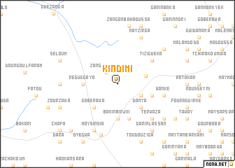
Kindimi (Zinder, Niger)Kindimi is a town in the Zinder region of Niger. An overview map of the region around Kindimi is displayed below.
regional and 3d topo map of Kindimi, Niger ::
Kindimi airports ::
The nearest airport is ZND - Zinder, located 63.9 km south of Kindimi.
Other airports nearby include MFG - Maradi (204.5 km south west), Nearby towns ::
Zangon Dassi (2.6km north west) //
Garin Makada (4.0km south east) //
Babouloua (4.5km east) //
Danya (5.2km south east) //
Gobérawa (5.2km south west) //
Bakin Birji II (5.6km south) //
Régué Gaya (5.4km west) //
Danya Maychabanou (5.8km south) //
Karanbana (5.7km east) //
Badoukay (6.5km north east) //
Tiziguéka (6.5km north east) //
Wanké (7.4km east) //
Terwaza (7.7km south east) //
May Sinsia (8.2km south west) //
Mayzirga (8.2km north east) //
Bakin Birji (8.5km south) //
Garin Lassan (9.2km south east) //
Mayodo (9.1km south east) //
El Hazeï (9.2km south east) //
Garin Aba (9.1km north east) //
Margaram (10.3km south west) //
[all distances 'as the bird flies' and approximate] 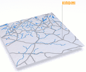 Places with similar names to Kindimi, Niger ::
Disclaimer :: Information on this page comes without warranty of any kind |
||
|
Where is Kindimi? Elevation and coordinates ::
Latitude (lat): 14°20'0"N Longitude (lon): 8°49'0"E
Elevation (approx.): 460m (map arrows pan, magnifying glasses zoom) |
||
|
Visiting Kindimi? Hotel/Accommodation ::
Book a hotel in Kindimi Travel Guide ::
Buy a travel guide for Niger rental cars ::
car rental offers GPS waypoint ::
download a GPX waypoint (PoI) of Kindimi for your GPS receiver
|
||