|
search place name
|
||
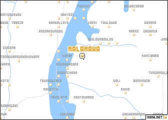
Malamawa (Dosso, Niger)Malamawa is a town in the Dosso region of Niger. An overview map of the region around Malamawa is displayed below.
regional and 3d topo map of Malamawa, Niger ::
Malamawa airports ::
The nearest airport is SKO - Sokoto Sadiq Abubakar Iii Intl, located 182.8 km east of Malamawa.
Other airports nearby include NIM - Niamey Diori Hamani (187.8 km north west), Nearby towns ::
Angoa Tamou (1.9km north) //
Mamaya (2.6km north west) //
Dafam (3.6km west) //
Angoa Daoura (4.1km south west) //
Rouan Chama (5.2km south west) //
Touloumboulou (5.2km north east) //
Angoa Doka Karama (5.4km west) //
Angoa Doka Baba (5.7km west) //
Guéza Gado (6.6km south west) //
Kalgo (6.6km north east) //
Karki (7.6km north) //
Guéza Rouga (7.8km south west) //
Guéza (7.8km south west) //
Balifolo (8.1km north east) //
Angoa Koundou (9.1km north west) //
Tourmouzawa (9.1km south west) //
Doli (9.1km south east) //
Toulouwa (9.2km north east) //
Angoa Rérey (9.2km north west) //
Hamdallaye (9.2km north west) //
Madotchi (10.4km south west) //
[all distances 'as the bird flies' and approximate] 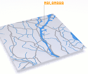 Places with similar names to Malamawa, Niger ::
Disclaimer :: Information on this page comes without warranty of any kind |
||
|
Where is Malamawa? Elevation and coordinates ::
Latitude (lat): 12°29'0"N Longitude (lon): 3°35'0"E
Elevation (approx.): 192m (map arrows pan, magnifying glasses zoom) |
||
|
Visiting Malamawa? Hotel/Accommodation ::
Book a hotel in Malamawa Travel Guide ::
Buy a travel guide for Niger rental cars ::
car rental offers GPS waypoint ::
download a GPX waypoint (PoI) of Malamawa for your GPS receiver
|
||