|
search place name
|
||
Mouri Dan Ladi (Maradi, Niger)Mouri Dan Ladi is a town in the Maradi region of Niger. An overview map of the region around Mouri Dan Ladi is displayed below.
regional and 3d topo map of Mouri Dan Ladi, Niger ::

Mouri Dan Ladi airports ::
The nearest airport is MFG - Maradi, located 52.8 km west of Mouri Dan Ladi.
Other airports nearby include ZND - Zinder (150.8 km east), QUS - Gusau (187.6 km south west), KAN - Kano Mallam Aminu Intl (200.5 km south east), Nearby towns ::
Mouri Makaoura (1.8km east) //
Doundoufawa (1.9km south) //
Guidan Bounou (2.6km south east) //
Mouri Dan Farou (2.6km south west) //
Guidan Dan May Gari (3.7km south) //
Dan Dounia (4.1km south west) //
Dan Kori (4.1km north west) //
Zongo Moussa (4.1km south west) //
Marin Dawa (5.4km west) //
May Gaoudé (5.4km east) //
Guidan Bouzou (6.6km north west) //
Tékelmawa (6.6km north east) //
Débi (7.4km south) //
Guidan Jigo (7.2km west) //
Alkou (7.6km north) //
Dan Gantamawa (7.4km east) //
Zabon Moussou (7.8km south west) //
Dan Bouzou (7.8km north west) //
Dogon Marké (7.8km north east) //
Naki Fada (8.1km north west) //
[all distances 'as the bird flies' and approximate] 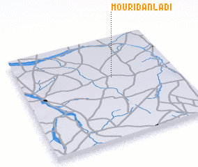 Places with similar names to Mouri Dan Ladi, Niger :: Disclaimer :: Information on this page comes without warranty of any kind |
||
|
Where is Mouri Dan Ladi? Elevation and coordinates ::
Latitude (lat): 13°37'0"N Longitude (lon): 7°36'0"E
Elevation (approx.): 424m (map arrows pan, magnifying glasses zoom) |
||
|
Visiting Mouri Dan Ladi? Hotel/Accommodation ::
Book a hotel in Mouri Dan Ladi Travel Guide ::
Buy a travel guide for Niger rental cars ::
car rental offers GPS waypoint ::
download a GPX waypoint (PoI) of Mouri Dan Ladi for your GPS receiver
|
||