|
search place name
|
||
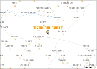
Bandioul Banté (Kaolack, Senegal)Bandioul Banté is a town in the Kaolack region of Senegal. An overview map of the region around Bandioul Banté is displayed below.
regional and 3d topo map of Bandioul Banté, Senegal ::
Bandioul Banté airports ::
The nearest airport is KLC - Kaolack, located 105.3 km west of Bandioul Banté.
Other airports nearby include TUD - Tambacounda (158.0 km east), BJL - Banjul Intl (186.3 km south west), ZIG - Ziguinchor (208.8 km south west), CSK - Cap Skiring (254.4 km south west), Nearby towns ::
Sintiou Adar (4.0km north east) //
Missira (4.0km south west) //
Por Tialène (4.0km south west) //
Port Daramé (4.0km north west) //
Arafa (4.1km north west) //
Médina Keur Lahine Mara (5.2km south west) //
Maka Yop (5.4km east) //
Ndakar (6.6km north east) //
Missira (6.6km south west) //
Tissé (7.4km north) //
Médina Tiarène (7.6km north) //
Guérane (7.7km north east) //
Mbaye Mbaye (8.2km south east) //
Sévane (8.1km south west) //
Aïnoumal (9.2km south west) //
Daro (10.3km south west) //
Keur Yoro Barou (10.3km north west) //
[all distances 'as the bird flies' and approximate] 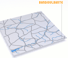 Places with similar names to Bandioul Banté, Senegal :: Disclaimer :: Information on this page comes without warranty of any kind |
||
|
Where is Bandioul Banté? Elevation and coordinates ::
Latitude (lat): 14°2'0"N Longitude (lon): 15°5'0"W
Elevation (approx.): 50m (map arrows pan, magnifying glasses zoom) |
||
|
Visiting Bandioul Banté? Hotel/Accommodation ::
Book a hotel in Bandioul Banté Travel Guide ::
Buy a travel guide for Senegal rental cars ::
car rental offers GPS waypoint ::
download a GPX waypoint (PoI) of Bandioul Banté for your GPS receiver
|
||