|
search place name
|
||
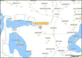
Kagnobon (Ziguinchor, Senegal)Kagnobon is a town in the Ziguinchor region of Senegal. An overview map of the region around Kagnobon is displayed below.
regional and 3d topo map of Kagnobon, Senegal ::
Kagnobon airports ::
The nearest airport is ZIG - Ziguinchor, located 35.1 km south east of Kagnobon.
Other airports nearby include CSK - Cap Skiring (59.5 km south west), BJL - Banjul Intl (60.3 km north west), BXO - Bissau Oswaldo Vieira Intl (133.9 km south east), KLC - Kaolack (149.8 km north), Nearby towns ::
Kabaline (2.6km south east) //
Béssiré (2.9km north west) //
Samouna (3.0km south) //
Tilaye (3.1km north east) //
Bougolor (5.7km south east) //
Diégoun (5.7km east) //
Dianki (5.8km north west) //
Pakao (6.3km south east) //
Kolonba (6.4km south east) //
Djimandé (6.8km south) //
Bélaye (7.1km north) //
Badiana (8.4km north) //
Sonkokounda (8.6km north) //
Baïla (9.3km north east) //
Baline (9.5km north west) //
Diounougé (9.7km north east) //
Balingor (10.1km south east) //
Baléou (10.7km south east) //
Kabalane (10.9km south west) //
Diakoye (11.2km north east) //
Etékome (11.3km south east) //
[all distances 'as the bird flies' and approximate]  Places with similar names to Kagnobon, Senegal ::
// Goacainabón (CU)
Disclaimer :: Information on this page comes without warranty of any kind |
||
|
Where is Kagnobon? Elevation and coordinates ::
Latitude (lat): 12°50'32"N Longitude (lon): 16°25'12"W
Elevation (approx.): 17m (map arrows pan, magnifying glasses zoom) |
||
|
Visiting Kagnobon? Hotel/Accommodation ::
Book a hotel in Kagnobon Travel Guide ::
Buy a travel guide for Senegal rental cars ::
car rental offers GPS waypoint ::
download a GPX waypoint (PoI) of Kagnobon for your GPS receiver
|
||