|
search place name
|
||
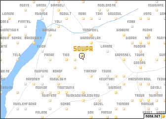
Soupa (Fatick, Senegal)Soupa is a town in the Fatick region of Senegal. An overview map of the region around Soupa is displayed below.
regional and 3d topo map of Soupa, Senegal ::
Soupa airports ::
The nearest airport is KLC - Kaolack, located 43.3 km south of Soupa.
Other airports nearby include BJL - Banjul Intl (139.9 km south), DKR - Dakar Leopold Sedar Senghor Intl (142.9 km west), XLS - St. Louis Saint Louis (172.4 km north), ZIG - Ziguinchor (217.2 km south), Nearby towns ::
Ndodj (1.8km west) //
Diourbel Sine (2.6km south west) //
Tiéo (3.6km west) //
Darou Salam (4.1km north east) //
Tiakmar (4.1km south east) //
Patar Lia (4.1km south east) //
Lamane (5.7km east) //
Diabel (5.7km east) //
Ténéfoul (5.8km north) //
Toune (6.5km south east) //
Bohof (6.5km south west) //
Farar (7.2km west) //
Sarhmak (7.4km south) //
Ndouloum (7.7km south west) //
Keur Yabi (7.7km south east) //
Gossas Village (8.1km south east) //
Tioutoune (8.2km south west) //
Yoli (9.2km north west) //
Bangadj (9.1km north west) //
Fandane (9.2km south west) //
Diender (10.3km south east) //
Tiaré Djilassèm (10.3km south west) //
[all distances 'as the bird flies' and approximate] 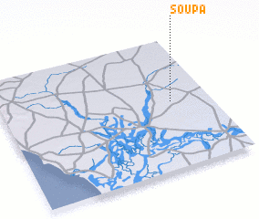 Places with similar names to Soupa, Senegal ::
Disclaimer :: Information on this page comes without warranty of any kind |
||
|
Where is Soupa? Elevation and coordinates ::
Latitude (lat): 14°31'0"N Longitude (lon): 16°11'0"W
Elevation (approx.): 20m (map arrows pan, magnifying glasses zoom) |
||
|
Visiting Soupa? Hotel/Accommodation ::
Book a hotel in Soupa Travel Guide ::
Buy a travel guide for Senegal rental cars ::
car rental offers GPS waypoint ::
download a GPX waypoint (PoI) of Soupa for your GPS receiver
|
||