|
search place name
|
||
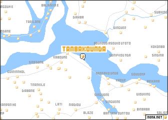
Tanbakounda (Ziguinchor, Senegal)Tanbakounda is a town in the Ziguinchor region of Senegal. An overview map of the region around Tanbakounda is displayed below.
regional and 3d topo map of Tanbakounda, Senegal ::
Tanbakounda airports ::
The nearest airport is ZIG - Ziguinchor, located 33.1 km west of Tanbakounda.
Other airports nearby include CSK - Cap Skiring (86.0 km west), BXO - Bissau Oswaldo Vieira Intl (87.5 km south east), BJL - Banjul Intl (107.9 km north west), KLC - Kaolack (169.5 km north), Nearby towns ::
Adéane (3.9km west) //
Diagnon (4.1km south) //
Kaniaka (4.5km south west) //
Koubone (4.9km south west) //
Kaboune (4.9km west) //
Sibink (5.7km west) //
Gonoum (6.0km west) //
Mangakounda (6.5km south east) //
Boumouda Soukoutoto (6.9km east) //
Kanéma (7.5km south east) //
Baganha (7.5km west) //
Sibikouroto (7.7km north east) //
Banganga (7.9km west) //
Sérifkounda (8.0km east) //
Diao (8.4km north) //
Diaw Ba (8.5km north) //
Kaour (9.9km south east) //
Singuèr (10.0km north east) //
[all distances 'as the bird flies' and approximate] 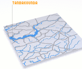 Places with similar names to Tanbakounda, Senegal :: Disclaimer :: Information on this page comes without warranty of any kind |
||
|
Where is Tanbakounda? Elevation and coordinates ::
Latitude (lat): 12°37'0"N Longitude (lon): 15°59'0"W
Elevation (approx.): 14m (map arrows pan, magnifying glasses zoom) |
||
|
Visiting Tanbakounda? Hotel/Accommodation ::
Book a hotel in Tanbakounda Travel Guide ::
Buy a travel guide for Senegal rental cars ::
car rental offers GPS waypoint ::
download a GPX waypoint (PoI) of Tanbakounda for your GPS receiver
|
||