|
search place name
|
||
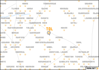
Tol (Louga, Senegal)Tol is a town in the Louga region of Senegal. An overview map of the region around Tol is displayed below.
regional and 3d topo map of Tol, Senegal ::
Tol airports ::
The nearest airport is XLS - St. Louis Saint Louis, located 106.6 km north west of Tol.
Other airports nearby include KLC - Kaolack (118.7 km south), DKR - Dakar Leopold Sedar Senghor Intl (172.2 km west), BJL - Banjul Intl (220.6 km south), Nearby towns ::
Tchabougueul (1.9km north) //
Ndiamaguène (1.9km south) //
Maka (4.1km north west) //
Nguessé (4.0km south west) //
Mbayène Ndjoudame (4.1km south west) //
Kermagano (4.1km south west) //
Pinnpal (4.0km south east) //
Sine (5.2km north west) //
Guennguer (5.4km west) //
Dabel (5.6km south) //
Mbaïlo (5.6km south) //
Bari (5.7km west) //
Makinn (5.7km east) //
Ndiourki (5.8km south) //
Koyélol (5.8km south) //
Merina (5.8km north) //
Nimsate (5.8km north) //
Touba Mérina (6.5km north west) //
Tialgou (7.4km west) //
Karatchel (7.6km south) //
Nger (7.7km south east) //
Dédali (8.2km north west) //
Ndakhar (9.1km south west) //
Ganao (9.1km south west) //
Mbande (9.1km north west) //
Lougré (9.2km south east) //
Mbéridiane (10.3km north west) //
Aladji Ali (10.3km north east) //
[all distances 'as the bird flies' and approximate]  Places with similar names to Tol, Senegal ::
Disclaimer :: Information on this page comes without warranty of any kind |
||
|
Where is Tol? Elevation and coordinates ::
Latitude (lat): 15°13'0"N Longitude (lon): 15°58'0"W
Elevation (approx.): 51m (map arrows pan, magnifying glasses zoom) |
||
|
Visiting Tol? Hotel/Accommodation ::
Book a hotel in Tol Travel Guide ::
Buy a travel guide for Senegal rental cars ::
car rental offers GPS waypoint ::
download a GPX waypoint (PoI) of Tol for your GPS receiver
|
||