|
search place name
|
||
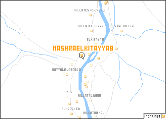
Mashra el Kitayyab (Nahr an Nīl, Sudan)Mashra el Kitayyab is a town in the Nahr an Nīl region of Sudan. An overview map of the region around Mashra el Kitayyab is displayed below.
regional and 3d topo map of Mashra el Kitayyab, Sudan ::
Mashra el Kitayyab airports ::
The nearest airport is KRT - Khartoum, located 211.6 km south west of Mashra el Kitayyab.
Nearby towns ::
El Gabrab (1.8km north east) //
Saqadi Shariq (2.1km south east) //
Ennuba Wad Fadniya (2.6km south west) //
Hillat Taboora (3.4km east) //
Mukabrabiya (3.9km south) //
El Kitayab (4.5km north east) //
Sayyal el ‘Ababda (4.9km south west) //
Hillat Qala‘t el Manaser (5.2km south) //
El Tafara (5.1km south west) //
El Mutmar (5.7km south) //
El Mutmar (6.3km south) //
Saqadi (6.3km south west) //
Hillat el Horra (6.7km north) //
Hillat Umm Mineqla (7.6km east) //
Qabati (8.8km north east) //
El Kimer (9.1km south) //
Hillat Alnitela (10.4km north east) //
[all distances 'as the bird flies' and approximate] 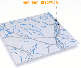 Places with similar names to Mashra el Kitayyab, Sudan :: Disclaimer :: Information on this page comes without warranty of any kind |
||
|
Where is Mashra el Kitayyab? Elevation and coordinates ::
Latitude (lat): 17°9'4"N Longitude (lon): 33°41'44"E
Elevation (approx.): 359m (map arrows pan, magnifying glasses zoom) |
||
|
Visiting Mashra el Kitayyab? Hotel/Accommodation ::
Book a hotel in Mashra el Kitayyab Travel Guide ::
Buy a travel guide for Sudan rental cars ::
car rental offers GPS waypoint ::
download a GPX waypoint (PoI) of Mashra el Kitayyab for your GPS receiver
|
||