|
search place name
|
||
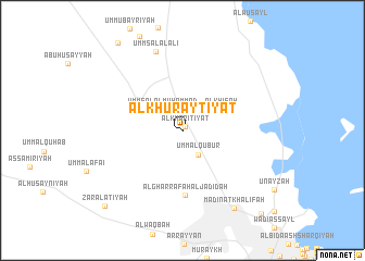
Al Khurayţīyāt (Qatar)Al Khurayţīyāt is a town in Qatar. An overview map of the region around Al Khurayţīyāt is displayed below.
regional and 3d topo map of Al Khurayţīyāt, Qatar ::
Al Khurayţīyāt airports ::
The nearest airport is DOH - Doha Intl, located 20.8 km south east of Al Khurayţīyāt.
Other airports nearby include BAH - Bahrain Intl (125.0 km north west), DHA - Dhahran King Abdulaziz Ab (159.6 km north west), LEA - Al-ahsa Al Ahsa (195.4 km west), DMM - Dammam King Fahd Intl (201.6 km north west), Nearby towns ::
Al Kharīţīyāt (0.4km north east) //
Umm al Qubūr (2.9km south east) //
Umm Şalāl Muḩammad (2.9km north west) //
Al Khīsah (4.2km north east) //
Al Gharrāfah al Jadīdah (6.6km south) //
Umm Şalāl ‘Alī (8.5km north) //
Madīnat Khalīfah (9.3km south east) //
Zar‘ al ‘Atīyah (10.7km south west) //
Al Markhīyah (11.2km south east) //
[all distances 'as the bird flies' and approximate] 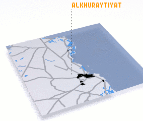 Places with similar names to Al Khurayţīyāt, Qatar ::
// Al Kharīţīyāt (QA)
Disclaimer :: Information on this page comes without warranty of any kind |
||
|
Where is Al Khurayţīyāt? Elevation and coordinates ::
Latitude (lat): 25°23'49"N Longitude (lon): 51°25'21"E
Elevation (approx.): 20m (map arrows pan, magnifying glasses zoom) |
||
|
Visiting Al Khurayţīyāt? Hotel/Accommodation ::
Book a hotel in Al Khurayţīyāt Travel Guide ::
Buy a travel guide for Qatar rental cars ::
car rental offers GPS waypoint ::
download a GPX waypoint (PoI) of Al Khurayţīyāt for your GPS receiver
|
||