|
search place name
|
||
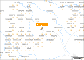
Kapara (Eastern, Zambia)Kapara is a town in the Eastern region of Zambia. An overview map of the region around Kapara is displayed below.
regional and 3d topo map of Kapara, Zambia ::
Kapara airports ::
The nearest airport is MFU - Mfuwe, located 69.0 km north west of Kapara.
Other airports nearby include LLW - Lilongwe Kamuzu Intl (140.1 km east), Nearby towns ::
Mbalo (1.9km south) //
Mchacha (1.9km south) //
Chikwanda (2.6km south east) //
Nyama (3.7km south) //
Mshawa (3.7km south) //
Kambutika (4.1km south east) //
Kamhatika (4.1km south west) //
Kalima (4.1km south west) //
Mose (4.1km north west) //
Chintona (5.2km south west) //
Chaola (5.2km south west) //
Maloza (5.6km south) //
Chimunka (5.6km south) //
Chigangeni (5.6km south) //
Saidi (5.7km west) //
Mlonveni (5.8km south) //
Mkanire (5.8km south) //
Maduma (5.8km south) //
Kachingwe (5.8km south) //
Chiminya (5.8km south) //
Chikolola (6.6km south east) //
Masupe (6.6km south east) //
Chiweteka (6.6km south west) //
Zamanga (6.6km south west) //
Undi (6.6km north east) //
Zalani (6.6km south west) //
Kawendama (6.6km south west) //
Kamphasa (6.6km south west) //
Chiparamba (6.6km south west) //
[all distances 'as the bird flies' and approximate] 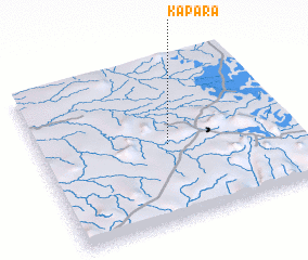 Places with similar names to Kapara, Zambia ::
Disclaimer :: Information on this page comes without warranty of any kind |
||
|
Where is Kapara? Elevation and coordinates ::
Latitude (lat): 13°31'0"S Longitude (lon): 32°31'0"E
Elevation (approx.): 939m (map arrows pan, magnifying glasses zoom) |
||
|
Visiting Kapara? Hotel/Accommodation ::
Book a hotel in Kapara Travel Guide ::
Buy a travel guide for Zambia rental cars ::
car rental offers GPS waypoint ::
download a GPX waypoint (PoI) of Kapara for your GPS receiver
|
||