|
search place name
|
||
Katanya (Northern, Zambia)Katanya is a town in the Northern region of Zambia. An overview map of the region around Katanya is displayed below.
regional and 3d topo map of Katanya, Zambia ::
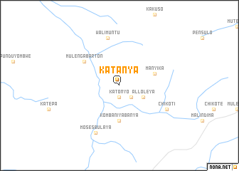
Nearby towns ::
Katonyo (1.9km south) //
Kampambwe (2.6km south east) //
Alloleya (4.1km south east) //
Komba Niyabanya (5.6km south) //
Manyika (5.8km east) //
Mulenga Barton (6.6km north west) //
Wa Limuntu (7.6km north) //
Chikoti (8.2km south east) //
Moses Bulaya (8.3km south west) //
[all distances 'as the bird flies' and approximate] 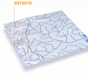 Places with similar names to Katanya, Zambia ::
// Gatnoye (UA)
// Kodnya (UA)
// Kadnoye (RU)
// Quţnīyah (IQ)
// Kadinya (UG)
// Guidan Ayo (NE)
// Guidan Iya (NE)
// Koutounèye (NE)
// Katanya (ZM)
// Katanya (ZM)
Disclaimer :: Information on this page comes without warranty of any kind |
||
|
Where is Katanya? Elevation and coordinates ::
Latitude (lat): 9°26'0"S Longitude (lon): 31°1'0"E
Elevation (approx.): 1383m (map arrows pan, magnifying glasses zoom) |
||
|
Visiting Katanya? Hotel/Accommodation ::
Book a hotel in Katanya Travel Guide ::
Buy a travel guide for Zambia rental cars ::
car rental offers GPS waypoint ::
download a GPX waypoint (PoI) of Katanya for your GPS receiver
|
||