|
search place name
|
||
Kutibiwa (Western, Zambia)Kutibiwa is a town in the Western region of Zambia. An overview map of the region around Kutibiwa is displayed below.
regional and 3d topo map of Kutibiwa, Zambia ::
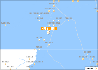
Nearby towns ::
Kwibisa (1.9km north) //
Mukenelekwa (1.9km north) //
Amoka (2.6km south west) //
Lwaneka (2.6km south west) //
Mukumbuta (3.7km north) //
Kalonga (3.7km south) //
Mwanangombe (4.1km north east) //
Mayapi (4.0km south west) //
Iluya (4.0km south west) //
Mela (5.8km north) //
Mundia (5.8km north) //
Inambao (5.8km north) //
Libonda (6.6km north west) //
Namiluko (6.6km north east) //
Nyaka (6.6km north west) //
Sikomo (6.6km north east) //
Situlu (6.6km south west) //
Lamukwena (7.7km south west) //
Simbunda (7.7km south west) //
Mulena Mbowanjikana (8.2km north west) //
Nangili (9.1km north east) //
[all distances 'as the bird flies' and approximate] 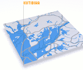 Places with similar names to Kutibiwa, Zambia ::
Disclaimer :: Information on this page comes without warranty of any kind |
||
|
Where is Kutibiwa? Elevation and coordinates ::
Latitude (lat): 14°57'0"S Longitude (lon): 23°0'0"E
Elevation (approx.): 1022m (map arrows pan, magnifying glasses zoom) |
||
|
Visiting Kutibiwa? Hotel/Accommodation ::
Book a hotel in Kutibiwa Travel Guide ::
Buy a travel guide for Zambia rental cars ::
car rental offers GPS waypoint ::
download a GPX waypoint (PoI) of Kutibiwa for your GPS receiver
|
||