|
search place name
|
||
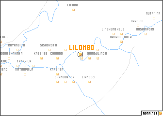
Lilombo (Western, Zambia)Lilombo is a town in the Western region of Zambia. An overview map of the region around Lilombo is displayed below.
regional and 3d topo map of Lilombo, Zambia ::
Nearby towns ::
Mushakabantu (0.0km north) //
Kakompe (0.0km north) //
Pumpola (1.8km east) //
Pumpola (2.6km north east) //
Kimina (2.6km north west) //
Kasaku (3.6km east) //
Shindulinga (3.6km east) //
Mukunchani (4.0km north east) //
Hoyoka (4.0km north west) //
Chiongo (5.4km west) //
Liambezi (5.8km south) //
Kashitiko (5.8km south) //
Kundendema (5.8km south) //
Kaposhi (6.6km south west) //
Kazakama (6.6km south west) //
Shamubanga (6.6km south west) //
Kambole (6.5km south west) //
Kapemba (6.5km south west) //
Mwanaumo (6.6km south west) //
Sishokota (7.4km west) //
Sanjamba (7.7km south west) //
Limbwembwele (9.1km north east) //
[all distances 'as the bird flies' and approximate]  Places with similar names to Lilombo, Zambia ::
Disclaimer :: Information on this page comes without warranty of any kind |
||
|
Where is Lilombo? Elevation and coordinates ::
Latitude (lat): 13°59'0"S Longitude (lon): 24°4'0"E
Elevation (approx.): 1059m (map arrows pan, magnifying glasses zoom) |
||
|
Visiting Lilombo? Hotel/Accommodation ::
Book a hotel in Lilombo Travel Guide ::
Buy a travel guide for Zambia rental cars ::
car rental offers GPS waypoint ::
download a GPX waypoint (PoI) of Lilombo for your GPS receiver
|
||