|
search place name
|
||
Mbwangu (Western, Zambia)Mbwangu is a town in the Western region of Zambia. An overview map of the region around Mbwangu is displayed below.
regional and 3d topo map of Mbwangu, Zambia ::
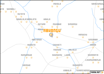
Nearby towns ::
Kaushenda (1.8km east) //
Likwaka (1.9km north) //
Muhongo (2.6km north east) //
Mangowa (2.6km north east) //
Mulumbami (3.7km north) //
Chivweti (4.1km south east) //
Ngumbwe (4.1km north east) //
Pokola (4.0km north west) //
Mutupa (5.2km north west) //
Manenga (5.8km south) //
Yawisha (5.8km south) //
Mboyonga (5.7km west) //
Wahila (5.8km north) //
Shungenu (7.6km south) //
Limbambo (7.7km north west) //
Singangu (8.1km north east) //
Mushita (8.1km south west) //
Naliele (9.1km south east) //
Mwene Mutondo (9.1km north west) //
Sapalata (9.1km north west) //
Liuha (9.2km south east) //
Masheka (10.3km south west) //
[all distances 'as the bird flies' and approximate] 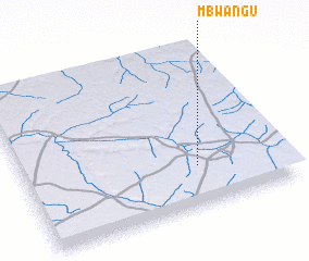 Places with similar names to Mbwangu, Zambia ::
Disclaimer :: Information on this page comes without warranty of any kind |
||
|
Where is Mbwangu? Elevation and coordinates ::
Latitude (lat): 14°45'0"S Longitude (lon): 24°40'0"E
Elevation (approx.): 1182m (map arrows pan, magnifying glasses zoom) |
||
|
Visiting Mbwangu? Hotel/Accommodation ::
Book a hotel in Mbwangu Travel Guide ::
Buy a travel guide for Zambia rental cars ::
car rental offers GPS waypoint ::
download a GPX waypoint (PoI) of Mbwangu for your GPS receiver
|
||