|
search place name
|
||
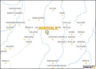
Mkangala (Eastern, Zambia)Mkangala is a town in the Eastern region of Zambia. An overview map of the region around Mkangala is displayed below.
regional and 3d topo map of Mkangala, Zambia ::
Mkangala airports ::
The nearest airport is MFU - Mfuwe, located 80.1 km north of Mkangala.
Nearby towns ::
Malili (0.0km north) //
Chimfesa (2.6km south east) //
Msondo (4.0km north east) //
Mzumwa (4.0km north west) //
Chimuka (5.4km west) //
Malunda (5.4km west) //
Chipapilo (5.7km east) //
Ngwalamambi (6.6km north west) //
Maukwalu (6.5km south east) //
Chitele (7.4km east) //
Kampata (7.4km west) //
Chilembwe (7.4km west) //
Mbenjere (7.4km west) //
Mchilwa (8.1km north east) //
Juliesi (8.1km north east) //
Masiri (8.1km south west) //
Mposi (9.2km north east) //
Mpangula (9.1km north west) //
[all distances 'as the bird flies' and approximate] 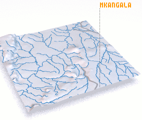 Places with similar names to Mkangala, Zambia ::
// Mugangale (MM)
// Maquencal (PA)
// Maquencal (PA)
// Maquencal (CO)
// Makingulu (CD)
// Makungulu (CD)
// Mokangulu (CD)
// Muakangolo (CD)
// Mua-Kongolo (CD)
// Mukungula (CD)
Disclaimer :: Information on this page comes without warranty of any kind |
||
|
Where is Mkangala? Elevation and coordinates ::
Latitude (lat): 13°56'0"S Longitude (lon): 31°40'0"E
Elevation (approx.): 866m (map arrows pan, magnifying glasses zoom) |
||
|
Visiting Mkangala? Hotel/Accommodation ::
Book a hotel in Mkangala Travel Guide ::
Buy a travel guide for Zambia rental cars ::
car rental offers GPS waypoint ::
download a GPX waypoint (PoI) of Mkangala for your GPS receiver
|
||