|
search place name
|
||
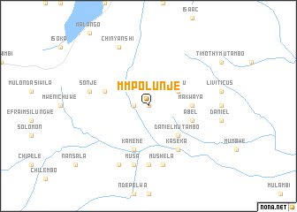
Mmpolunje (Northern, Zambia)Mmpolunje is a town in the Northern region of Zambia. An overview map of the region around Mmpolunje is displayed below.
regional and 3d topo map of Mmpolunje, Zambia ::
Mmpolunje airports ::
The nearest airport is KGJ - Karonga, located 130.0 km east of Mmpolunje.
Other airports nearby include ZZU - Mzuzu (196.2 km south east), Nearby towns ::
Mbulunje (0.0km north) //
Chapoto (1.8km west) //
Waingu (4.1km north east) //
Daniel Mutambo (5.2km south east) //
Chipepeya (5.5km east) //
Makwaya (5.5km east) //
Kameme (5.9km south) //
Chuwi (5.8km west) //
Abel (5.8km east) //
Kaseka (6.6km south east) //
Chumanembo (7.4km south) //
Sonje (7.5km west) //
Musa (7.6km south) //
Beneya (7.6km south) //
Mushela (7.6km south) //
Chinyanshi (8.3km north west) //
Chisakula (8.3km south west) //
[all distances 'as the bird flies' and approximate]  Places with similar names to Mmpolunje, Zambia ::
// Mapulange (MZ)
Disclaimer :: Information on this page comes without warranty of any kind |
||
|
Where is Mmpolunje? Elevation and coordinates ::
Latitude (lat): 10°12'0"S Longitude (lon): 32°44'0"E
Elevation (approx.): 1402m (map arrows pan, magnifying glasses zoom) |
||
|
Visiting Mmpolunje? Hotel/Accommodation ::
Book a hotel in Mmpolunje Travel Guide ::
Buy a travel guide for Zambia rental cars ::
car rental offers GPS waypoint ::
download a GPX waypoint (PoI) of Mmpolunje for your GPS receiver
|
||