|
search place name
|
||
Muzila (Western, Zambia)Muzila is a town in the Western region of Zambia. An overview map of the region around Muzila is displayed below.
regional and 3d topo map of Muzila, Zambia ::
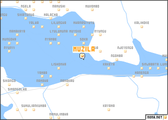
Nearby towns ::
Mwenda (2.6km north east) //
Soka (3.7km north) //
Nyeyengo (3.7km north) //
Mbumwae (4.0km north east) //
Mulope (5.8km north) //
Kakeya (5.7km east) //
Lishomwa (5.7km west) //
Muyeke (5.8km north) //
Chamba (6.6km north east) //
Kambwanga (6.6km north east) //
Nyungu (6.6km north east) //
Namakau (6.6km south west) //
Munganya (6.5km north west) //
Ngomba (7.2km east) //
Mwanasitutu (7.4km north) //
Lyulumuna (7.7km north west) //
Sindandumuna (8.1km south west) //
Nyambe (8.1km north west) //
Lilungwa (9.2km north west) //
[all distances 'as the bird flies' and approximate] 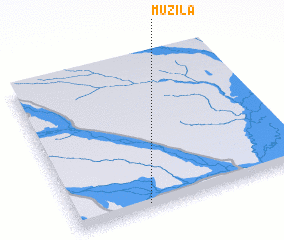 Places with similar names to Muzila, Zambia ::
Disclaimer :: Information on this page comes without warranty of any kind |
||
|
Where is Muzila? Elevation and coordinates ::
Latitude (lat): 14°58'0"S Longitude (lon): 22°19'0"E
Elevation (approx.): 1029m (map arrows pan, magnifying glasses zoom) |
||
|
Visiting Muzila? Hotel/Accommodation ::
Book a hotel in Muzila Travel Guide ::
Buy a travel guide for Zambia rental cars ::
car rental offers GPS waypoint ::
download a GPX waypoint (PoI) of Muzila for your GPS receiver
|
||