|
search place name
|
||
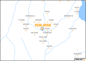
Ngalande (Eastern, Zambia)Ngalande is a town in the Eastern region of Zambia. An overview map of the region around Ngalande is displayed below.
regional and 3d topo map of Ngalande, Zambia ::
Ngalande airports ::
The nearest airport is LLW - Lilongwe Kamuzu Intl, located 105.2 km east of Ngalande.
Other airports nearby include MFU - Mfuwe (133.2 km north west), Nearby towns ::
Mzewe (1.8km east) //
Chimwendo (2.6km south east) //
Kalikongwe (2.6km north east) //
Kamunyenga (3.6km east) //
Kavilawa (3.7km south) //
Kalonga (4.0km south west) //
Chimuzimu (4.0km south west) //
Chikoma (4.1km north east) //
Mangani (4.1km north west) //
Guma (4.1km north west) //
Vubwe (5.2km north east) //
Chapita (5.2km north west) //
Kalumpe (5.2km north west) //
Mulemba (5.6km south) //
Tenje (5.7km east) //
Mkoko (7.2km west) //
Mponda (7.4km west) //
Pundi (7.6km north) //
Kapandula (7.7km north west) //
Kanena (7.7km north west) //
Bulimo (8.3km south) //
[all distances 'as the bird flies' and approximate]  Places with similar names to Ngalande, Zambia ::
// Ngalando (CM)
// Nykland (NO)
// Nicolinţ (RO)
// Ngalanda (CF)
// Nikalanda (LK)
// Nikalanda (LK)
// Nakalundu (ZM)
// Niguélandé (GN)
// Nkalunta (NG)
// Niquelândia (BR)
Disclaimer :: Information on this page comes without warranty of any kind |
||
|
Where is Ngalande? Elevation and coordinates ::
Latitude (lat): 14°4'0"S Longitude (lon): 32°51'0"E
Elevation (approx.): 852m (map arrows pan, magnifying glasses zoom) |
||
|
Visiting Ngalande? Hotel/Accommodation ::
Book a hotel in Ngalande Travel Guide ::
Buy a travel guide for Zambia rental cars ::
car rental offers GPS waypoint ::
download a GPX waypoint (PoI) of Ngalande for your GPS receiver
|
||