|
search place name
|
||
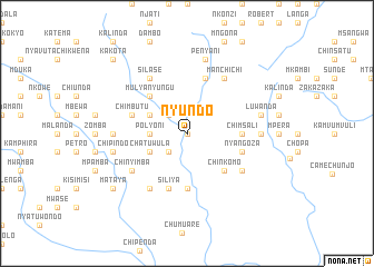
Nyundo (Eastern, Zambia)Nyundo is a town in the Eastern region of Zambia. An overview map of the region around Nyundo is displayed below.
regional and 3d topo map of Nyundo, Zambia ::
Nyundo airports ::
The nearest airport is MFU - Mfuwe, located 128.6 km north of Nyundo.
Other airports nearby include LLW - Lilongwe Kamuzu Intl (221.5 km east), TET - Tete Chingodzi (269.4 km south east), Nearby towns ::
Nchofu (0.0km north) //
Nyanjeta (0.0km north) //
Kawenda (2.6km south west) //
Kamowa (2.6km south west) //
Kalowa (2.6km north west) //
Polyoni (3.6km west) //
Chatuwula (4.0km south west) //
Nyanje (4.0km north west) //
Mulyanyungu (5.2km north west) //
Chinkomo (5.2km south east) //
Kansundila (5.6km south) //
Chimsali (5.4km east) //
Siliya (5.8km south) //
Chimusale (5.7km east) //
Kalendo (5.7km east) //
Nyangoza (5.7km east) //
Chimbutu (5.7km west) //
Chapuka (5.8km north) //
Chithumba (6.6km south west) //
Silase (6.6km north west) //
Carinda (6.5km south east) //
Chinyimba (6.5km south west) //
Mposa (6.6km north west) //
Mulungwe (6.6km north west) //
Chibweya (6.5km south west) //
Kapapa (6.6km north east) //
Chatuluka (6.6km north east) //
Manchichi (6.6km north east) //
Simfunka (7.2km west) //
[all distances 'as the bird flies' and approximate]  Places with similar names to Nyundo, Zambia ::
Disclaimer :: Information on this page comes without warranty of any kind |
||
|
Where is Nyundo? Elevation and coordinates ::
Latitude (lat): 14°25'0"S Longitude (lon): 31°50'0"E
Elevation (approx.): 994m (map arrows pan, magnifying glasses zoom) |
||
|
Visiting Nyundo? Hotel/Accommodation ::
Book a hotel in Nyundo Travel Guide ::
Buy a travel guide for Zambia rental cars ::
car rental offers GPS waypoint ::
download a GPX waypoint (PoI) of Nyundo for your GPS receiver
|
||