|
search place name
|
||
Samahongo (Western, Zambia)Samahongo is a town in the Western region of Zambia. An overview map of the region around Samahongo is displayed below.
regional and 3d topo map of Samahongo, Zambia ::
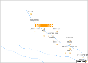
Nearby towns ::
Nyambe (0.0km north) //
Upangi (1.9km south) //
Sabindonga (2.6km south east) //
Kachakana (2.6km south east) //
Chikeso (3.6km west) //
Chingavata (3.6km west) //
Makwita Makai (4.0km south east) //
Sinjabata (5.2km north west) //
Someno (5.2km south east) //
Kavatula (5.2km south east) //
Likwasi (5.4km east) //
Likubi (7.7km south east) //
Museta (7.7km south east) //
Ponde (9.2km north west) //
[all distances 'as the bird flies' and approximate] 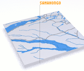 Places with similar names to Samahongo, Zambia ::
// Siĕm Hong (KH)
// Samahongo (CD)
// Samahungu (CD)
// Samahongo (ZM)
// Simahongo (ZM)
// Samhŭng (KR)
// Xóm Bà Hương (VN)
// Xóm Hai Ngọ (VN)
// Xóm Hàng (VN)
// Xóm Hung (VN)
Disclaimer :: Information on this page comes without warranty of any kind |
||
|
Where is Samahongo? Elevation and coordinates ::
Latitude (lat): 13°59'0"S Longitude (lon): 22°14'0"E
Elevation (approx.): 1058m (map arrows pan, magnifying glasses zoom) |
||
|
Visiting Samahongo? Hotel/Accommodation ::
Book a hotel in Samahongo Travel Guide ::
Buy a travel guide for Zambia rental cars ::
car rental offers GPS waypoint ::
download a GPX waypoint (PoI) of Samahongo for your GPS receiver
|
||