|
search place name
|
||
Simambwa (Western, Zambia)Simambwa is a town in the Western region of Zambia. An overview map of the region around Simambwa is displayed below.
regional and 3d topo map of Simambwa, Zambia ::
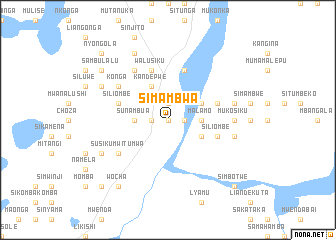
Nearby towns ::
Seshonda (0.0km north) //
Salimbunda (0.0km north) //
Liyuma (0.0km north) //
Sunamuna (0.0km north) //
Liamu (1.8km east) //
Kalaluka (1.8km east) //
Mushola (1.9km north) //
Sakumbe (1.9km north) //
Kasheba (1.9km north) //
Mwanangumune (1.8km west) //
Chifi (1.8km west) //
Malamo (3.6km east) //
Ngoma (3.6km west) //
Kangongwe (3.6km west) //
Sunambua (3.6km west) //
Likombo (3.6km west) //
Siliambe (4.0km south east) //
Safundula (4.0km north east) //
Kandepwe (4.1km north west) //
Siliombe (5.7km east) //
Njekwa (5.7km east) //
Lishahala (5.7km east) //
Mushawa Liomba (5.8km north) //
Siliombe (5.7km west) //
Walusiku (5.8km north) //
Susiku Mwitumwa (6.5km south west) //
Liseka (6.6km north west) //
Chisonda (6.6km north west) //
Konga (6.5km north west) //
[all distances 'as the bird flies' and approximate] 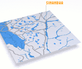 Places with similar names to Simambwa, Zambia ::
// Simambwe (ZM)
Disclaimer :: Information on this page comes without warranty of any kind |
||
|
Where is Simambwa? Elevation and coordinates ::
Latitude (lat): 15°40'0"S Longitude (lon): 23°36'0"E
Elevation (approx.): 1030m (map arrows pan, magnifying glasses zoom) |
||
|
Visiting Simambwa? Hotel/Accommodation ::
Book a hotel in Simambwa Travel Guide ::
Buy a travel guide for Zambia rental cars ::
car rental offers GPS waypoint ::
download a GPX waypoint (PoI) of Simambwa for your GPS receiver
|
||