|
search place name
|
||
Singandu (Western, Zambia)Singandu is a town in the Western region of Zambia. An overview map of the region around Singandu is displayed below.
regional and 3d topo map of Singandu, Zambia ::
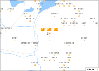
Nearby towns ::
Situmbaeto (0.0km north) //
Sinyinda (1.9km south) //
Tobolo (6.5km south west) //
Nyambi (6.5km north east) //
Chinkumbe (7.6km south) //
Mubiana (7.6km north) //
Matengo (7.7km north east) //
Nakakena (8.0km south east) //
Samuya (8.0km north east) //
Chinganda (8.0km north east) //
Liumi (9.0km north west) //
Sivauya (9.0km north west) //
Sonda (10.3km south east) //
Musitwana (10.3km north west) //
[all distances 'as the bird flies' and approximate] 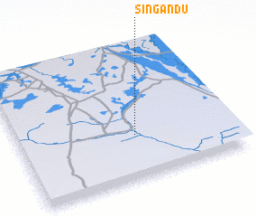 Places with similar names to Singandu, Zambia ::
// Xankǝndi (AZ)
// Xankǝndi (AZ)
// Cinquanta (IT)
// Sanguineto (IT)
// Sangoñedo (ES)
// Sanguiñeda (ES)
// Sanguiñedo (ES)
// Sanguñedo (ES)
// Sengānti (BD)
// Sonāikāndi (BD)
Disclaimer :: Information on this page comes without warranty of any kind |
||
|
Where is Singandu? Elevation and coordinates ::
Latitude (lat): 15°40'0"S Longitude (lon): 22°33'0"E
Elevation (approx.): 1032m (map arrows pan, magnifying glasses zoom) |
||
|
Visiting Singandu? Hotel/Accommodation ::
Book a hotel in Singandu Travel Guide ::
Buy a travel guide for Zambia rental cars ::
car rental offers GPS waypoint ::
download a GPX waypoint (PoI) of Singandu for your GPS receiver
|
||