|
search place name
|
||
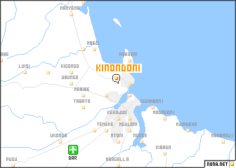
Kinondoni (Tanzania)Kinondoni is a town in Tanzania. An overview map of the region around Kinondoni is displayed below.
regional and 3d topo map of Kinondoni, Tanzania ::
Kinondoni airports ::
The nearest airport is DAR - Dar Es Salaam Mwalimu Julius K Nyerere Intl, located 12.6 km south west of Kinondoni.
Other airports nearby include ZNZ - Zanzibar (62.2 km north), PMA - Pemba (179.2 km north), TGT - Tanga (188.2 km north), Nearby towns ::
Oyster Bay (1.8km east) //
Dar es Salaam (2.6km south east) //
Sea View (2.6km south east) //
Magomeni (2.6km south west) //
Msasani (4.1km north east) //
Changombe (5.6km south) //
Ilala (5.6km south) //
Keko Juu (5.6km south) //
Keko Chini (5.9km south) //
Mabibe (5.8km west) //
Kigamboni (6.6km south east) //
Mbezi (6.7km north west) //
Tabata (6.6km south west) //
Ubungo (7.4km west) //
Kigongo (7.6km west) //
Kurasini (7.6km south) //
Mgulani (7.6km south) //
Temeke (7.6km south) //
Kawi (7.8km north west) //
Mtambani (8.3km south west) //
Magogoni (9.2km south east) //
[all distances 'as the bird flies' and approximate] 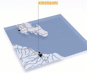 Places with similar names to Kinondoni, Tanzania ::
Disclaimer :: Information on this page comes without warranty of any kind |
||
|
Where is Kinondoni? Elevation and coordinates ::
Latitude (lat): 6°47'0"S Longitude (lon): 39°16'0"E
Elevation (approx.): 14m (map arrows pan, magnifying glasses zoom) |
||
|
Visiting Kinondoni? Hotel/Accommodation ::
Book a hotel in Kinondoni Travel Guide ::
Buy a travel guide for Tanzania rental cars ::
car rental offers GPS waypoint ::
download a GPX waypoint (PoI) of Kinondoni for your GPS receiver
|
||