|
search place name
|
||
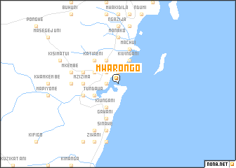
Mwarongo (Tanzania)Mwarongo is a town in Tanzania. An overview map of the region around Mwarongo is displayed below.
regional and 3d topo map of Mwarongo, Tanzania ::
Mwarongo airports ::
The nearest airport is TGT - Tanga, located 13.8 km north of Mwarongo.
Other airports nearby include PMA - Pemba (80.8 km east), ZNZ - Zanzibar (112.3 km south), MBA - Mombasa Moi Intl (142.5 km north east), DAR - Dar Es Salaam Mwalimu Julius K Nyerere Intl (184.2 km south), Nearby towns ::
Tangata (1.8km west) //
Tongoni (1.8km west) //
Tambarani (1.8km west) //
Kiwavu (1.9km north) //
Wanga (2.6km north west) //
Sadani (2.6km north west) //
Kiungani (4.1km south west) //
Tundaua (4.1km south west) //
Lumbwa (4.1km north west) //
Darigube (4.1km north west) //
Kivindani (4.1km north east) //
Katipeni (5.2km north west) //
Mzizima (5.5km west) //
Geza (5.8km west) //
Gawani (5.9km south) //
Majonjo (5.8km west) //
Manyumbe (5.8km west) //
Migombani (5.8km west) //
Machui (5.9km north) //
Marungu (7.4km west) //
Manako (7.4km north) //
Sinawe (7.6km south) //
Kolekole (7.6km west) //
Mkembe (7.6km west) //
Mchangani (8.3km south west) //
[all distances 'as the bird flies' and approximate] 
Disclaimer :: Information on this page comes without warranty of any kind |
||
|
Where is Mwarongo? Elevation and coordinates ::
Latitude (lat): 5°13'0"S Longitude (lon): 39°5'0"E
Elevation (approx.): -32768m (map arrows pan, magnifying glasses zoom) |
||
|
Visiting Mwarongo? Hotel/Accommodation ::
Book a hotel in Mwarongo Travel Guide ::
Buy a travel guide for Tanzania rental cars ::
car rental offers GPS waypoint ::
download a GPX waypoint (PoI) of Mwarongo for your GPS receiver
|
||