|
search place name
|
||
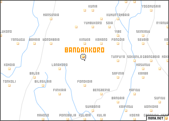
Bandankoro (Northern, Sierra Leone)Bandankoro is a town in the Northern region of Sierra Leone. An overview map of the region around Bandankoro is displayed below.
regional and 3d topo map of Bandankoro, Sierra Leone ::
Bandankoro airports ::
The nearest airport is FAA - Faranah, located 137.5 km north east of Bandankoro.
Other airports nearby include FNA - Freetown Lungi (206.1 km west), Nearby towns ::
Kindea (3.7km north) //
Kamaro (5.2km north east) //
Forokoia (5.6km south) //
Lanakoro (5.8km west) //
Tunfuya (7.3km east) //
Yumbukoro (7.6km north) //
Farakoro (7.6km north) //
Bengberia (8.3km south east) //
Safinia (8.2km south east) //
Fangoia (8.2km north east) //
Worombaia (8.2km north west) //
Firikaia (9.2km south west) //
Yibe (9.2km north east) //
Soia (9.2km north east) //
[all distances 'as the bird flies' and approximate]  Places with similar names to Bandankoro, Sierra Leone ::
// Ban Don Khrai (TH)
// Ban Don Kra (TH)
// Ban Don Kruai (TH)
// Ban Ting Rai (TH)
// Ban Ting Rai (TH)
// Banda Āngāria (BD)
// Bandankoro (SL)
// Bandankoro (SL)
// Bandanékoro (GN)
// Bandankoro (GN)
Disclaimer :: Information on this page comes without warranty of any kind |
||
|
Where is Bandankoro? Elevation and coordinates ::
Latitude (lat): 8°56'0"N Longitude (lon): 11°21'0"W
Elevation (approx.): 397m (map arrows pan, magnifying glasses zoom) |
||
|
Visiting Bandankoro? Hotel/Accommodation ::
Book a hotel in Bandankoro Travel Guide ::
rental cars ::
car rental offers GPS waypoint ::
download a GPX waypoint (PoI) of Bandankoro for your GPS receiver
|
||