|
search place name
|
||
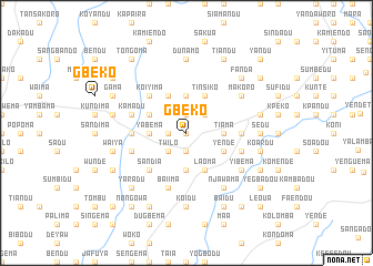
Gbeko (Eastern, Sierra Leone)Gbeko is a town in the Eastern region of Sierra Leone. An overview map of the region around Gbeko is displayed below.
regional and 3d topo map of Gbeko, Sierra Leone ::
Gbeko airports ::
The nearest airport is FAA - Faranah, located 159.3 km north of Gbeko.
Nearby towns ::
Fuero (0.0km north) //
Kalia (1.8km west) //
Kungamadu (1.9km south) //
Nyandeama (1.9km north) //
Yamaro (2.6km south west) //
Kainfodu (2.6km north east) //
Twilo (2.6km south west) //
Foidu (3.7km south) //
Yabema (3.7km west) //
Dukono (3.7km south) //
Tama (3.7km north) //
Tiama (3.7km east) //
Laoma (4.1km south east) //
Bandko (4.1km north west) //
Sanankoreko (4.1km south east) //
Bate (4.1km north west) //
Yende (4.1km south east) //
Gbamundu (4.1km north west) //
Tinsiko (4.1km north east) //
Sandia (5.2km south west) //
Koiyima (5.2km north west) //
Kania (5.5km west) //
Gboidu (5.5km east) //
Kagbema (5.8km west) //
Kamadu (5.8km west) //
Baiima (5.9km south) //
Dagbu (5.8km east) //
Kpendima (5.8km east) //
Njawama (6.7km south east) //
[all distances 'as the bird flies' and approximate]  Places with similar names to Gbeko, Sierra Leone ::
Disclaimer :: Information on this page comes without warranty of any kind |
||
|
Where is Gbeko? Elevation and coordinates ::
Latitude (lat): 8°36'0"N Longitude (lon): 10°39'0"W
Elevation (approx.): 346m (map arrows pan, magnifying glasses zoom) |
||
|
Visiting Gbeko? Hotel/Accommodation ::
Book a hotel in Gbeko Travel Guide ::
rental cars ::
car rental offers GPS waypoint ::
download a GPX waypoint (PoI) of Gbeko for your GPS receiver
|
||