|
search place name
|
||
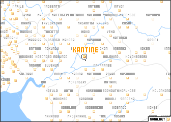
Kantine (Southern, Sierra Leone)Kantine is a town in the Southern region of Sierra Leone. An overview map of the region around Kantine is displayed below.
regional and 3d topo map of Kantine, Sierra Leone ::
Kantine airports ::
The nearest airport is FNA - Freetown Lungi, located 50.4 km north west of Kantine.
Nearby towns ::
Kumrabai (1.9km south) //
Gbailo (2.6km north west) //
Mojusu (2.6km north west) //
Moniambe (2.6km north east) //
Botima (2.6km south east) //
Kigbal (3.7km north) //
Madina (4.1km south west) //
Gbangba (4.1km south west) //
Masanka (4.1km north east) //
Matonko (4.1km south east) //
Rokon (4.1km north east) //
Makarambe (4.1km south east) //
Makoba (5.2km north west) //
Ribimakeni (5.2km south west) //
Konta (5.2km north east) //
Makoi (5.6km north) //
Molamina (5.5km east) //
Ro-bunga (5.5km west) //
Mosogbul (5.5km west) //
Jabama (5.9km north) //
Mofengeri (5.9km south) //
Gbane (5.8km west) //
Rowal (6.6km south east) //
Makeson (6.6km north west) //
Ribimen (6.6km south west) //
Fabaina (7.3km west) //
Masantigi (7.4km north) //
Ma-selo (7.6km west) //
Ma-suri (7.6km west) //
[all distances 'as the bird flies' and approximate]  Places with similar names to Kantine, Sierra Leone ::
Disclaimer :: Information on this page comes without warranty of any kind |
||
|
Where is Kantine? Elevation and coordinates ::
Latitude (lat): 8°18'0"N Longitude (lon): 12°52'0"W
Elevation (approx.): 16m (map arrows pan, magnifying glasses zoom) |
||
|
Visiting Kantine? Hotel/Accommodation ::
Book a hotel in Kantine Travel Guide ::
rental cars ::
car rental offers GPS waypoint ::
download a GPX waypoint (PoI) of Kantine for your GPS receiver
|
||