|
search place name
|
||
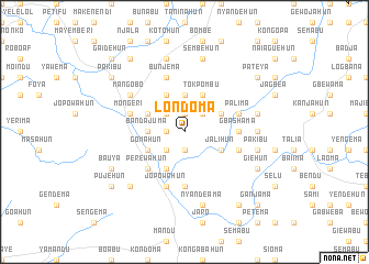
Londoma (Southern, Sierra Leone)Londoma is a town in the Southern region of Sierra Leone. An overview map of the region around Londoma is displayed below.
regional and 3d topo map of Londoma, Sierra Leone ::
Londoma airports ::
The nearest airport is FNA - Freetown Lungi, located 170.2 km west of Londoma.
Other airports nearby include FAA - Faranah (216.6 km north east), Nearby towns ::
Konima (1.9km north) //
Manjehun (1.9km south) //
Belebu (1.8km west) //
Benduma (2.6km north east) //
Nyandehun (2.6km south west) //
Wunde (2.6km north west) //
Petema (3.7km north) //
Bandajuma (3.7km west) //
Giebu (4.1km north east) //
Tokpombu (4.1km north east) //
Bokuma (4.1km north east) //
Perewahun (4.1km north west) //
Jalihun (4.1km south east) //
Hewebu (4.1km south west) //
Gomahun (4.1km south west) //
Nayema (4.1km north west) //
Perewahun (5.2km south west) //
Gbashama (5.5km east) //
Giema (5.6km south) //
Naiahun (5.8km east) //
Bunjema (5.9km north) //
Palima (5.8km east) //
Mongeri (5.8km west) //
Jopowahun (5.9km south) //
Mangobo (6.6km north west) //
Garahun (7.3km east) //
Bahama (7.6km east) //
Pakibu (7.6km east) //
Sembehun (7.6km north) //
[all distances 'as the bird flies' and approximate]  Places with similar names to Londoma, Sierra Leone ::
Disclaimer :: Information on this page comes without warranty of any kind |
||
|
Where is Londoma? Elevation and coordinates ::
Latitude (lat): 8°18'0"N Longitude (lon): 11°41'0"W
Elevation (approx.): 180m (map arrows pan, magnifying glasses zoom) |
||
|
Visiting Londoma? Hotel/Accommodation ::
Book a hotel in Londoma Travel Guide ::
rental cars ::
car rental offers GPS waypoint ::
download a GPX waypoint (PoI) of Londoma for your GPS receiver
|
||