|
search place name
|
||
Luseni (Western Area, Sierra Leone)Luseni is a town in the Western Area region of Sierra Leone. An overview map of the region around Luseni is displayed below.
regional and 3d topo map of Luseni, Sierra Leone ::

Luseni airports ::
The nearest airport is FNA - Freetown Lungi, located 38.7 km north west of Luseni.
Nearby towns ::
Ma-konkwe (0.5km north west) //
Boikandu (0.8km south west) //
Yamba Town (0.9km north west) //
Masuri (0.9km south east) //
Mabiri (1.1km south) //
Bubu Town (1.3km south west) //
Joe Town (1.5km north west) //
Mokabi (1.6km north east) //
Sherbro Town (1.7km north east) //
Boikandu (1.8km south west) //
Mafonike (1.9km south) //
Ma-mange (1.9km south east) //
Ma-gbafti (1.9km east) //
Koker Town (2.1km west) //
Bagbamma (2.3km north) //
Masine (2.3km south east) //
Ma-lumbe (2.3km west) //
Kono Town (2.4km north) //
Ro-gberri (2.4km east) //
Ma-suri (2.5km south east) //
Joe Town (2.7km south) //
Konte (2.7km south east) //
Gendima (2.7km west) //
Katu Town (2.8km north east) //
Yandahu (2.9km north) //
Ma-konte (3.0km south) //
Ma-koi Lunga (3.1km south east) //
Mano (3.2km west) //
Campbell Town (3.2km west) //
[all distances 'as the bird flies' and approximate] 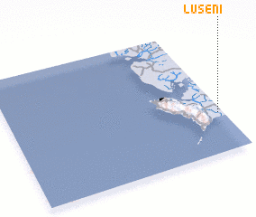 Places with similar names to Luseni, Sierra Leone ::
Disclaimer :: Information on this page comes without warranty of any kind |
||
|
Where is Luseni? Elevation and coordinates ::
Latitude (lat): 8°18'44"N Longitude (lon): 13°1'17"W
Elevation (approx.): 27m (map arrows pan, magnifying glasses zoom) |
||
|
Visiting Luseni? Hotel/Accommodation ::
Book a hotel in Luseni Travel Guide ::
rental cars ::
car rental offers GPS waypoint ::
download a GPX waypoint (PoI) of Luseni for your GPS receiver
|
||