|
search place name
|
||
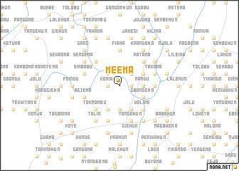
Meema (Eastern, Sierra Leone)Meema is a town in the Eastern region of Sierra Leone. An overview map of the region around Meema is displayed below.
regional and 3d topo map of Meema, Sierra Leone ::
Meema airports ::
The nearest airport is MLW - Monrovia Spriggs Payne, located 202.0 km south of Meema.
Other airports nearby include FAA - Faranah (215.6 km north), ROB - Monrovia Roberts Intl (218.1 km south), Nearby towns ::
Bendu (1.8km east) //
Konia (1.8km west) //
Yumbuma (2.6km north west) //
Goyama (2.6km north east) //
Komende-Luyama (3.7km south) //
Mandu (3.7km east) //
Teibo (4.1km south west) //
Bandi (4.1km south east) //
Konovulahun (4.1km north east) //
Gbangema (4.1km south east) //
Tokpombu (5.2km south west) //
Walima (5.2km south east) //
Patama (5.2km north east) //
Gogehun (5.2km north west) //
Fiama (5.6km north) //
Koyama (5.5km east) //
Gaahun (5.9km south) //
Nyadehun (5.9km south) //
Yangahun (5.9km south) //
Simbabu (5.8km west) //
Yakama (5.8km east) //
Petema (5.8km west) //
Talia (6.7km south west) //
Giema (6.7km south east) //
Masahun (6.7km south east) //
Sendema (6.6km north west) //
Kpandoma (6.7km north east) //
Jopowahun (6.6km north east) //
Foindu (7.3km west) //
[all distances 'as the bird flies' and approximate]  Places with similar names to Meema, Sierra Leone ::
Disclaimer :: Information on this page comes without warranty of any kind |
||
|
Where is Meema? Elevation and coordinates ::
Latitude (lat): 8°6'0"N Longitude (lon): 11°0'0"W
Elevation (approx.): 243m (map arrows pan, magnifying glasses zoom) |
||
|
Visiting Meema? Hotel/Accommodation ::
Book a hotel in Meema Travel Guide ::
rental cars ::
car rental offers GPS waypoint ::
download a GPX waypoint (PoI) of Meema for your GPS receiver
|
||