|
search place name
|
||
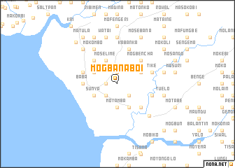
Mogbanaboi (Southern, Sierra Leone)Mogbanaboi is a town in the Southern region of Sierra Leone. An overview map of the region around Mogbanaboi is displayed below.
regional and 3d topo map of Mogbanaboi, Sierra Leone ::
Mogbanaboi airports ::
The nearest airport is FNA - Freetown Lungi, located 60.5 km north west of Mogbanaboi.
Nearby towns ::
Magbanawil (1.9km north) //
Mokasi (1.8km west) //
Mosebonkane (2.6km south east) //
Mobure (2.6km south west) //
Mosako (3.6km north east) //
Moyamba (3.7km south) //
Magburkise (4.1km north east) //
Moselime (4.1km north west) //
Batbai (4.1km north west) //
Makumba (4.1km south east) //
Sunya (4.1km south west) //
Mogbencha (5.2km north east) //
Magbanasatia (5.2km north west) //
Makoande (5.2km south east) //
Baba (5.5km west) //
Makanbu (5.8km west) //
Kabanka (5.9km north) //
Balo (5.8km east) //
Tike (5.8km east) //
Mabake (5.8km east) //
Mokombo (6.7km north west) //
Matobon (7.2km south east) //
Molamina (7.4km north) //
Balo (7.6km east) //
Tuelo (7.6km east) //
Watai (7.6km north) //
Moyamba (7.8km north west) //
Mosebana (8.3km north east) //
Kagbindi (8.3km north west) //
[all distances 'as the bird flies' and approximate]  Places with similar names to Mogbanaboi, Sierra Leone :: Disclaimer :: Information on this page comes without warranty of any kind |
||
|
Where is Mogbanaboi? Elevation and coordinates ::
Latitude (lat): 8°10'0"N Longitude (lon): 12°53'0"W
Elevation (approx.): 20m (map arrows pan, magnifying glasses zoom) |
||
|
Visiting Mogbanaboi? Hotel/Accommodation ::
Book a hotel in Mogbanaboi Travel Guide ::
rental cars ::
car rental offers GPS waypoint ::
download a GPX waypoint (PoI) of Mogbanaboi for your GPS receiver
|
||