|
search place name
|
||
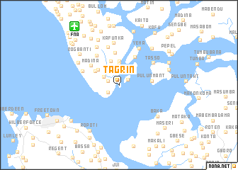
Tagrin (Northern, Sierra Leone)Tagrin is a town in the Northern region of Sierra Leone. An overview map of the region around Tagrin is displayed below.
regional and 3d topo map of Tagrin, Sierra Leone ::
Tagrin airports ::
The nearest airport is FNA - Freetown Lungi, located 11.5 km north west of Tagrin.
Other airports nearby include FIG - Fira Fria (206.6 km north), Nearby towns ::
Yelkakrom (1.6km north east) //
Tadi (1.9km west) //
Kupr (2.0km south west) //
Rogbom (2.6km north west) //
Rogberay (3.3km north) //
Gberi (3.8km north) //
Mamanki (4.0km north) //
Rosint (4.0km north west) //
Rosint (4.3km north west) //
Yeliba (5.0km north) //
Mabaki (5.1km north east) //
Pulunmant (5.1km east) //
Madina (5.3km north west) //
Sumbuya (5.8km north west) //
Cotton Tree (6.1km west) //
Royenkala (6.2km north) //
Tasso (6.3km north east) //
Kafunka (6.7km north) //
Yema (6.7km north east) //
Maloko (6.9km north west) //
Kagbeli (7.3km north west) //
Robis (7.7km north west) //
Tonko (7.7km north east) //
Rogbanti (7.7km north west) //
Baka (7.7km south east) //
Tasoku (8.0km east) //
Yema (8.4km north west) //
Sangbalima (8.5km north east) //
Ro-poti (8.5km south west) //
[all distances 'as the bird flies' and approximate] 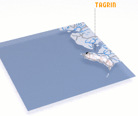 Places with similar names to Tagrin, Sierra Leone ::
Disclaimer :: Information on this page comes without warranty of any kind |
||
|
Where is Tagrin? Elevation and coordinates ::
Latitude (lat): 8°32'0"N Longitude (lon): 13°8'0"W
Elevation (approx.): -32768m (map arrows pan, magnifying glasses zoom) |
||
|
Visiting Tagrin? Hotel/Accommodation ::
Book a hotel in Tagrin Travel Guide ::
rental cars ::
car rental offers GPS waypoint ::
download a GPX waypoint (PoI) of Tagrin for your GPS receiver
|
||