|
search place name
|
||
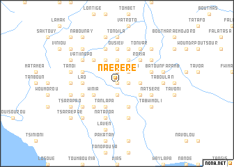
Naéréré (Sanma, Vanuatu)Naéréré is a town in the Sanma region of Vanuatu. An overview map of the region around Naéréré is displayed below.
regional and 3d topo map of Naéréré, Vanuatu ::
Nearby towns ::
Tsaraépéla (0.0km north) //
Roupési (1.9km south) //
Vousin (1.8km east) //
Kaïntsouro (1.8km east) //
Paten (1.8km east) //
Batounklao (1.8km east) //
Malori (1.8km east) //
Founpat (1.9km north) //
Nosousou (2.6km north east) //
Kouptana (2.6km north east) //
Fortsenal (2.6km north east) //
Taoumanouni (3.6km east) //
Tataïkalo (3.6km east) //
Boutnavaga (3.7km north) //
Bilbilou (4.1km south east) //
Kérentavou (4.0km south east) //
Morioul (4.0km south east) //
Naroutoli (4.0km south east) //
Batounboaen (4.1km south west) //
Tanlapa (4.1km south west) //
Vatounaki (4.0km south west) //
Méraroua (4.1km north east) //
Winia (4.0km south west) //
Morgrif (4.1km north east) //
Oroïbao (4.1km north west) //
Kérentavou (5.1km south west) //
Roria (5.1km north east) //
Bigeïlan (5.1km north west) //
Batounaéré (5.1km north west) //
[all distances 'as the bird flies' and approximate]  Places with similar names to Naéréré, Vanuatu ::
Disclaimer :: Information on this page comes without warranty of any kind |
||
|
Where is Naéréré? Elevation and coordinates ::
Latitude (lat): 15°28'0"S Longitude (lon): 166°52'0"E
Elevation (approx.): 461m (map arrows pan, magnifying glasses zoom) |
||
|
Visiting Naéréré? Hotel/Accommodation ::
Book a hotel in Naéréré Travel Guide ::
Buy a travel guide for Vanuatu rental cars ::
car rental offers GPS waypoint ::
download a GPX waypoint (PoI) of Naéréré for your GPS receiver
|
||