|
search place name
|
||
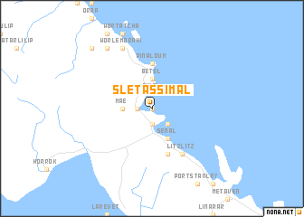
Slétassimal ((( Malakula )), Vanuatu)Slétassimal is a town in the (( Malakula )) region of Vanuatu. An overview map of the region around Slétassimal is displayed below.
regional and 3d topo map of Slétassimal, Vanuatu ::
Slétassimal airports ::
The nearest airport is VLI - Port-vila Port Vila Bauerfield, located 205.5 km south east of Slétassimal.
Nearby towns ::
Slelouré (0.0km north) //
Aop (1.9km south) //
Tivel (1.9km north) //
Norsup (1.8km west) //
Taoutou (2.6km south east) //
Chinohouse (2.6km north west) //
Maé (3.6km west) //
Bétel (3.7km north) //
Sénal (4.1km south east) //
Oussélé (4.1km south east) //
Plamaé (4.0km north west) //
Pinaloum (5.6km north) //
Lakatoro (5.8km south) //
Litzlitz (6.6km south east) //
Tichlélamboué (8.2km north west) //
Worlembraki (8.2km north west) //
Outèr (9.1km north west) //
Tomboul (10.3km north west) //
[all distances 'as the bird flies' and approximate] 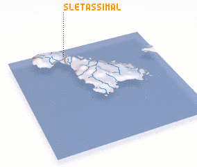 Places with similar names to Slétassimal, Vanuatu ::
// Slades Mill (US)
Disclaimer :: Information on this page comes without warranty of any kind |
||
|
Where is Slétassimal? Elevation and coordinates ::
Latitude (lat): 16°4'0"S Longitude (lon): 167°24'0"E
Elevation (approx.): 21m (map arrows pan, magnifying glasses zoom) |
||
|
Visiting Slétassimal? Hotel/Accommodation ::
Book a hotel in Slétassimal Travel Guide ::
Buy a travel guide for Vanuatu rental cars ::
car rental offers GPS waypoint ::
download a GPX waypoint (PoI) of Slétassimal for your GPS receiver
|
||