|
search place name
|
||
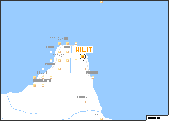
Wilit ((( Ambrym )), Vanuatu)Wilit is a town in the (( Ambrym )) region of Vanuatu. An overview map of the region around Wilit is displayed below.
regional and 3d topo map of Wilit, Vanuatu ::
Wilit airports ::
The nearest airport is VLI - Port-vila Port Vila Bauerfield, located 173.9 km south of Wilit.
Nearby towns ::
Lonwar (1.8km west) //
Fonteng (1.9km north) //
Konkon (1.9km south) //
Baréréo (2.6km north west) //
Falibeur (2.6km north west) //
Fontengro (2.6km north west) //
Fantiékon (3.6km west) //
Néha (3.6km west) //
Lolibwé (3.6km west) //
Tobol (4.0km north west) //
Woo (4.0km north west) //
Melbulbul (4.0km north west) //
Lonyemyem (4.0km north west) //
Lonbarnié (4.0km north west) //
Tawor (4.0km north west) //
Bogor (4.0km north west) //
Harimal (4.1km north west) //
Fonwor (4.1km south east) //
Lonha (5.1km north west) //
Olal (5.1km north west) //
Fanla (5.3km west) //
Lonré (5.3km west) //
Métamli (5.3km west) //
Nehatlin (5.3km west) //
Ranhor (5.3km west) //
Neubul (5.7km west) //
Likon (5.7km west) //
Fanouatatao (5.7km west) //
Métanwar (5.7km west) //
[all distances 'as the bird flies' and approximate]  Places with similar names to Wilit, Vanuatu ::
Disclaimer :: Information on this page comes without warranty of any kind |
||
|
Where is Wilit? Elevation and coordinates ::
Latitude (lat): 16°8'0"S Longitude (lon): 168°11'0"E
Elevation (approx.): 113m (map arrows pan, magnifying glasses zoom) |
||
|
Visiting Wilit? Hotel/Accommodation ::
Book a hotel in Wilit Travel Guide ::
Buy a travel guide for Vanuatu rental cars ::
car rental offers GPS waypoint ::
download a GPX waypoint (PoI) of Wilit for your GPS receiver
|
||