|
search place name
|
||
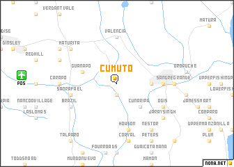
Cumuto (Saint Andrew, Trinidad and Tobago)Cumuto is a town in the Saint Andrew region of Trinidad and Tobago. An overview map of the region around Cumuto is displayed below.
regional and 3d topo map of Cumuto, Trinidad and Tobago ::
Cumuto airports ::
The nearest airport is POS - Port-of-spain Piarco, located 15.1 km west of Cumuto.
Other airports nearby include TAB - Scarborough Crown Point (74.4 km north east), GUI - Guiria (121.8 km west), GND - Point Salines Intl (169.7 km north), TUV - Tucupita (192.2 km south west), Nearby towns ::
Hasnalli (1.9km south) //
Cunaripa (5.2km south east) //
Guaico (5.5km east) //
Guanapo (5.8km west) //
Valencia (7.4km north) //
Cunapo (7.3km east) //
Howson (7.6km south) //
San Rafael (7.5km west) //
Brazil (8.2km south west) //
Cheeyou (8.2km south east) //
Ogis (8.2km south east) //
Nestor (9.2km south east) //
Maturita (9.2km north west) //
Jaraysingh (9.2km south east) //
[all distances 'as the bird flies' and approximate] 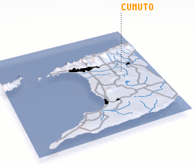 Places with similar names to Cumuto, Trinidad and Tobago ::
Disclaimer :: Information on this page comes without warranty of any kind |
||
|
Where is Cumuto? Elevation and coordinates ::
Latitude (lat): 10°35'0"N Longitude (lon): 61°12'0"W
Elevation (approx.): 53m (map arrows pan, magnifying glasses zoom) |
||
|
Visiting Cumuto? Hotel/Accommodation ::
Book a hotel in Cumuto Travel Guide ::
rental cars ::
car rental offers GPS waypoint ::
download a GPX waypoint (PoI) of Cumuto for your GPS receiver
|
||